Treasure Lakes 
Distance: 5.4 - 8.2 miles
John Muir Wilderness, Inyo National Forest, near Bishop in California's Southeastern Sierra
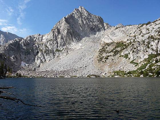
The first Treasure Lake
The Treasure Lakes trail travels to a beautiful, less visited granite lakes basin surrounded by talus slopes at the foot of Mount Thompson, Mount Goode and Hurd Peak.
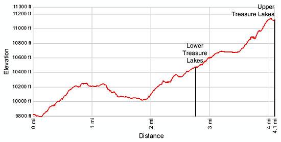
- Distance: 5.4 miles (round trip) to Lower Treasure Lakes
8.2 miles (round trip) to Upper Treasure Lakes - Elevation: 9,820-ft. at Trailhead
10,686-ft. at Lower Treasure Lakes
11,200-ft. at Upper Treasure Lakes - Elevation Gain: 866-ft. to Lower Treasure Lakes
1,380-ft. to Upper Treasure Lakes - Difficulty: moderate-strenuous
- Basecamp: Bishop / Mammoth Lakes
- Region: California's Southeastern Sierra
Trail Description - Treasure Lakes
Starting from the south end of the trailhead parking area the Treasure Lakes / Bishop Pass trail makes a short descent before it begins climbing at a steady pace along the east side of South Lake (9,768-ft.). The open trail offers wonderful views of the peaks ringing the lakes basin, including Hurd Peak (12,237-ft.), Mt. Thompson (13,494-ft.) and Mt. Goode (13,085-ft.).
A half mile from the start the trail turns left (southeast), passes through a small drainage and then makes a sharp right (southwest) turn back toward the lake. The trail now enters a forest of aspen and lodgepole pines, reaching the border of the John Muir Wilderness at 0.7 miles and the junction to Treasure Lakes trail at 0.8 miles
Turn right (south) at the junction and follow the Treasure Lakes trail as it climbs a granite bench above the southeastern shore. (The trail branching to the left (southeast) heads towards Bishop Pass.) At the 1 miles mark the trail curves to the southwest, losing about 230-ft. in 0.6 miles as it swings around the south end of the lake, dropping into a pretty drainage along the way.
At 1.6 miles the climb resumes. Soon the trees thin as the path ascends a succession of granite benches on moderate to moderately steep grades, gaining 650-ft. in a little over a mile. At the top of the climb reach the first two Treasure Lakes. The picturesque lakes (10, 686-ft) are located in a beautiful granite basin surrounded by talus slopes at the foot of Mount Thompson, Mount Goode and Hurd Peak, 2.7 miles from the trailhead.
Hikers with the time and energy might want to visit to the upper Treasure Lakes by following a use trail between the first and second lakes and then ascending a steep drainage, keeping to the west (right) of the outlet stream for the upper lakes flows. Thick vegetation about 0.3 miles up the drainage will force hikers to climb a minor granite escarpment to the right (west) of the drainage. The 0.2 mile climb gains about 100-ft. before reaching a flat area where you need to veer left to reach the two upper lakes (11,160-ft. and 11,200-ft.), located 3.7 and 4.1 miles from the trailhead.
Elevation Profile
Driving Directions
From Bishop: From US Highway 395 in downtown Bishop, turn west on Line Street /Highway 168. Follow Line Street / Highway 168 for 15 miles and turn left on to South Lake Road. Follow South Lake Road for 7.1 miles to the trailhead, located at the end of the road. Overflow parking is located along the road near Parchers Camp, less than a mile from South Lake. The trailhead is at the south end of the trailhead parking lot, to the left of the bathrooms.
From Mammoth Lakes: Drive 3.1 miles southeast on Main Street / CA 203 E and turn right onto the entrance ramp for US 395 S. Follow US 395 south for 39.1 miles to Bishop and turn right (west) on Line Street /Highway 168. Follow Line Street / Highway 168 for 15 miles and turn left on to South Lake Road. Follow South Lake Road for 7.1 miles to the trailhead, located at the end of the road. Overflow parking is located along the road near Parchers Camp, less than a mile from South Lake. The trailhead is at the south end of the trailhead parking lot, to the left of the bathrooms.
Trail Resources
- Trail Photo Gallery
- Trail Maps
- Basecamp(s) Information: Bishop / Mammoth Lakes
- Region Information: California's Southeastern Sierra
- Other Hiking Regions in: California