Numa Ridge 
Distance: 11.8 miles (round trip)
Glacier National Park, near West Glacier in Glacier Natl Park, MT
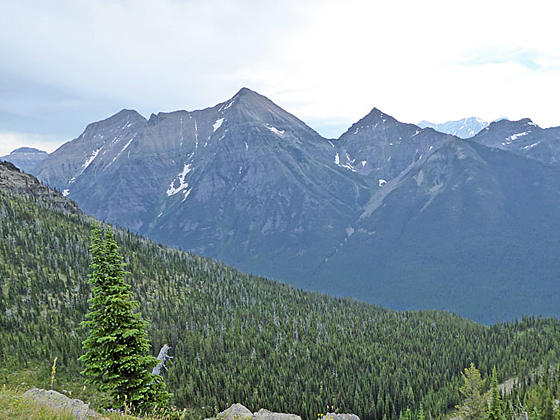
A lovely drive up Glacier’s North Fork Valley leads to Bowman Lake. Here the Numa Ridge trail climbs its namesake ridge to a working fire tower with fine views of the peaks rising along the southeast side of the lake and west across the North Fork Valley.
See Trail Detail/Full Description
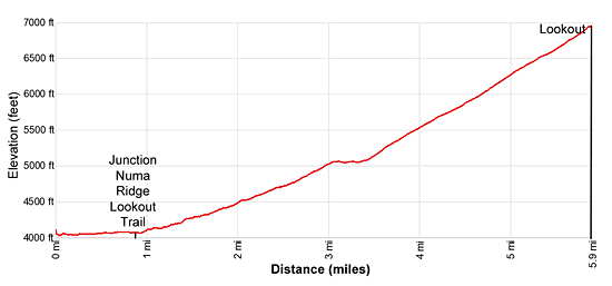
- Distance: 11.8 miles (round trip) to Numa Ridge Lookout
- Elevation: 4,030-ft. at Trailhead
6,960-ft. at Numa Ridge Lookout - Elevation Gain: 2,930-ft. to Numa Ridge Lookout
- Difficulty: moderate-strenuous
- More Hikes in:
Lake McDonald / Glacier Natl Park, MT
Why Hike Numa Ridge
Looking for a little solitude? Then take a hike to the Numa Ridge Lookout high above Bowman Lake in Glacier’s North Fork, located in the remote northwestern corner of the park. The drive to the trailhead takes 90 minutes on unpaved roads but is quite scenic and passes through the interesting town of Polebridge, a hamlet that is literally off the grid. Few visitors to the park venture this far afield so you are likely to have the trail mostly to yourself.
The trail starts from the foot of Bowman Lake, a beautiful 7.0 miles long lake ringed by high peaks. After swinging around the foot of the lake the trail climbs through forest up the slopes of Numa Ridge to a working fire lookout atop the ridge at 6,960-ft. Panoramic views extend east to the high peaks rising along the far side of the lake and beyond, south and west to the summits rising above the North Fork Valley and north to Reuter and Kintla Peaks in the Akokala Valley.
To maximize your enjoyment of the area consider spending a night camping at either Bowman or Kintla Lake (to the north). Both lakes are great spots of kayaking and canoeing. Other worthwhile trails in the area are the Quartz Lake Loop and the Boulder Pass trail along the north side of Kintla Lake.
A four-wheel drive or all-wheel drive vehicle is recommended for negotiating the bumpy and dusty roads. Check at the visitor center for current road conditions. Visitor should plan on being self-sufficient. Be sure to have a full tank of gas before setting out. Services are only available at the community of Polebridge. Cell phones will not work.
Elevation Profile

Trail Resources
Trail Detail/Full Description / Trail Photo Gallery / Trail Map
Basecamp(s) Information:
Lake McDonald
Region Information:
Glacier Natl Park, MT
Other Hiking Regions in:
Montana
