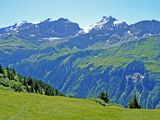
Running between Klausen Pass and Altdorf, the Schachental Hohenweg trail travels high above the north side of the Schachental Valley in the Schwyz Alps with panoramic views of the Glarus Alps to the south and the rugged cliffs of the Schachentaler Windgallen massif towering overhead.
See Trail Detail/Full Description
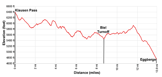
- Distance: 9.5 miles (one way) to Biel
13.9 miles (one way) to Eggberge - Elevation: 6,400-ft. at Trailhead
5,337-ft. at Biel
4,712-ft. at Eggberge - Elevation Gain: -1,063-ft. to Biel
-1,688-ft. to Eggberge - Difficulty: moderate-strenuous
- More Hikes in:
Altdorf / The Bernese Oberland
Why Hike Klausen Pass to Eggberge
This lovely walk follows the Schachental Hohenweg, a panoramic trail traveling high above the north side of the Schachental Valley between Klausen Pass and Altdorf. The path is a roller coaster, repeatedly ascending and descending as it crosses ridges and dips into drainage channels. The effort is rewarded with stunning views down the length of the Schachental Valley. The high peaks of the Glarus Alps tower above the valley to the south while rugged ridges of the Schachentaler Windgallen massif rise above the trail.
Klausen Pass (6,400-ft.), a relatively low pass between Linthal and Altdorf, is crossed by a popular road. Regularly scheduled Postbuses climb to the pass facilitating this scenic point-to-point hike that leads from the pass to Biel in 9.5 miles or Eggberge in 13.9 miles walk. Both options use lifts to descend back to the valley floor.
Elevation Profile

Support our Site | |
Trail Resources
Trail Detail/Full Description / Trail Photo Gallery / Trail Map
Basecamp(s) Information:
Altdorf
Region Information:
The Bernese Oberland
Other Hiking Regions in:
Switzerland

