Courthouse Butte Loop 
Distance: 3.8 - 4.4 miles
Munds Mountain Wilderness, Coconino National Forest, near Sedona in Arizona's Red Rock Country
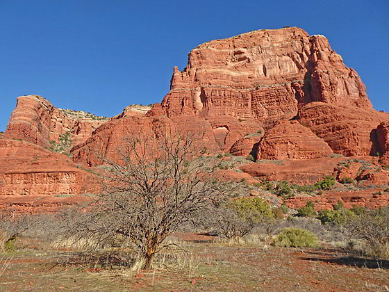
Courthouse Butte
This scenic loop hike features beautiful desert scenery and stunning views of Bell Rock and Courthouse Butte along with nearby Sedona red rock landmarks including Twin Buttes, Capitol Butte, Cathedral Rock and the Seven Warriors.
- Distance: 3.8 - 4.4 miles (Loop)
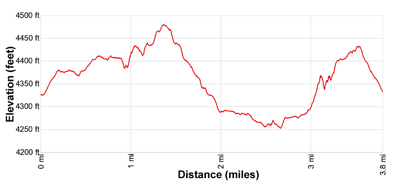
- Elevation: 4,350-ft. at Trailhead
Maximum elevation - 4,480-ft. - Elevation Gain: 130-ft.
- Difficulty: moderate
- Basecamp: Sedona
- Region: Arizona's Red Rock Country
Trail Description - Courthouse Butte Loop
The Courthouse Butte loop can be walked in either direction. This description describes the hike in a clock-wise direction starting at the Courthouse Vista trailhead. It is also possible to access the loop from the Bell Rock Vista trailhead to the south.
Note: There is little shade along the trail, making this a very hot hike in the summer. Sections of the trail are shared by bikes and horses.
From the Courthouse Vista trailhead (see driving directions below), head south on a broad trail that ascends on easy grades toward Bell Rock. Views encompass the Seven Warrior ridge across the highway to the west. Bell Rock and Courthouse Butte dominate the views to the south/southeast while Peak 5896 fills the skyline to the northeast (behind you). After 0.15 miles reach a signed junction and turn left (east) on the Courthouse Butte Loop.
The undulating path, marked by large cairns, now heads northeast through junipers, pinyon pines, manzanita, cacti, agave and desert brush, passing to the north of Bell Rock. As you walk enjoy views of Capitol Butte to the northwest and Twin Buttes to the north. The long ridge of Peak 5896 fills the skyline to the northeast while Courthouse Butte towers above the trail to the southeast. Soon views open northwest to Cathedral Rock.
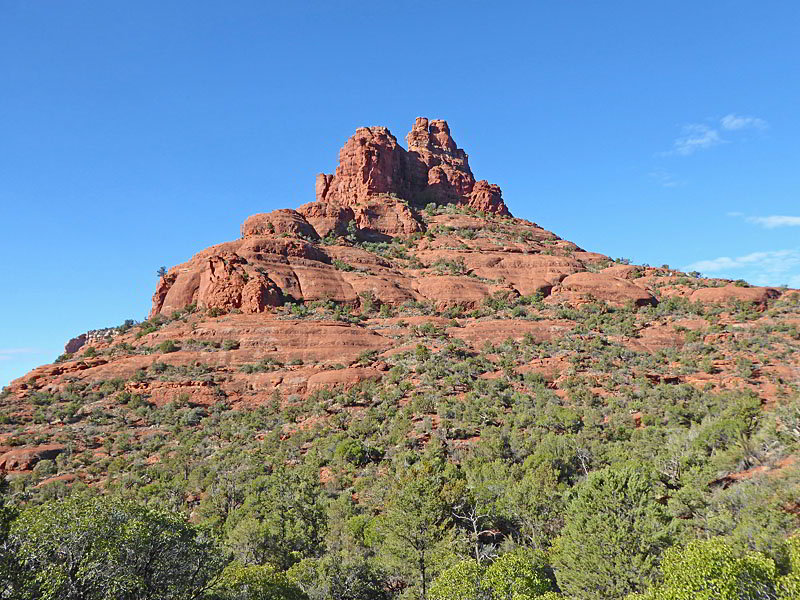
After 0.5 miles the trail passes the Bell Rock Pathway, branching left, and starts ascending on easy grades. A short distance beyond the path goes by the Llama Trail, also branching left, and then enters the Munds Mountain Wilderness. (No bikes allowed beyond this point.). Look back (southwest) for a great view of Bell Rock’s distinctive profile. Courthouse Butte soars overhead to the south.
The undulating trail now narrows as it continues east along the north side of Courthouse Butte, crossing a few drainages along the way. This section of the trail offers plenty of spots to stop and admire the prominent red rock formation, both near and far.
At 1.2 miles the trail curves to the right (southeast) and ascends toward a rounded red rock formation known as Muffin Rock. Rugged crags dominate the view to the west while the interesting northeast flanks of Courthouse Butte tower overhead.
Past Muffin Rock the trail crests a saddle and starts descending on easy to moderately-easy grades. Along the way the trail passes out of the Munds Mountain Wilderness and curves to the south/southwest beneath the east facing flanks of Courthouse Butte.
At 2.0 miles the path crosses a wash and then briefly descends along the east side of the wash. Reach a junction at 2.1 miles where the Big Park Loop head south, eventually leading to the Bell Rock Vista Trailhead. We turn right (west) and cross the wash on the continuation of the Courthouse Butte Loop trail.
After climbing out of the wash the path follows an undulated track beneath the south side of Courthouse Butte. Soon the path emerges onto open meadows with fine views of the Butte. Straight ahead (west) the Seven Warrior Ridge fill the skyline.
Pass the Middle Trail, branching left (south), at 2.4 miles and the east end of the Big Park Loop, branching left (south), at 2.7 miles. (Both of these trails can be used to reach the Bell Rock Vista Trailhead.) Views now encompass Bell Rock and the southwestern flanks of Courthouse Butte.
Reach a junction at 2.8 miles. Here you have two options. The first option continues straight ahead on the Courthouse Butte Loop, which reaches a junction with the Bell Rock Pathway in 0.3 miles. Turn right on the Bell Rock Pathway, which curves around the west side of Bell Rock, paralleling the highway on its return to the Courthouse Vista trailhead in 0.7 miles.
My preferred option is to turn right (north) on the Rector Connector trail for a more scenic return to the Courthouse Vista trailhead. The Rector Connector trail ascends on moderately-easy grade up brushy slopes along the east side of the drainage between Bell Rock and Courthouse Butte accompanied by great views of both formations. Along the way the trail passes back into the Munds Mountain Wilderness. At 3.3 miles reach a junction atop a slickrock saddle at the head of the drainage. The path now turns left (west) and ascends the slopes of Bell Rock to a bench along its north facing slopes.
Both the saddle and the bench enjoy stunning views of Capitol Butte, Twin Buttes, Chapel of the Holy Cross, Peak 5896, Airport Mesa and, in the distance to the north/northwest, Brins Mesa and Bear Mountain. The path now continues heading west along the flanks of Bell Rock to the junction with the Bell Rock Climb trail at 3.5 mile. (Turn left if you wish to climb the route, marked with cairns, up the formation.)
To complete the Courthouse Butte Loop turn right at the junction, descending on moderate grades down the Bell Rock Climb trail. The path soon passes out of the Munds Mountain Wilderness and reaches a junction at 3.65 miles. At the junction, bear right (north) on the trail pointing toward the Courthouse Vista parking area. The path now descends on gentle grades to the parking area at 3.8 miles.
Starting the Loop from the Bell Rock Vista Trailhead
Note: This starting point adds 0.6 miles round-trip to the trail as described above.
If starting from the Bell Rock Vista Trailhead, head west on the Bell Rock Pathway for a short distance to a junction. Bear right on the Bell Rock Pathway spur toward the Big Park Loop and then turn left (north/northeast) on the Big Park Loop to the Courthouse Butte Loop. Total distance to the Courthouse Butte Loop is 0.6 miles. (This junction is located at the 2.7 miles mark in the description above.) Turn left to walk the Courthouse Butte Loop trail in the clock-wise direction.
If you look at the maps at the Bell Rock Vista Trailhead you will see several other options for reaching the Courthouse Loop Trail. Keep in mind that both the Bell Rock Pathway and the Big Park loop are open to mountain bikes.
Elevation Profile
Driving Directions
Driving Directions from Sedona to the Courthouse Vista Trailhead: From the traffic circle at the intersection of Arizona State Roads 89A and 179 head south on Arizona 179 for 5.0 miles. Use the left lane marked for Courthouse Vista to turn left and then carefully cross the northbound traffic lane to the trailhead parking area located on the east side of the road. The turn is a short distance beyond Yavapai Point Vista. This lot is smaller than the Bell Rock Vista trailhead to the south. Both lots fill early but have a good amount of turnover since most people only walk to Bell Rock.
Note: a Red Rock Pass, America the Beautiful Interagency Pass, Golden Age Pass or Golden Access Pass is required to park in the lot. Red Rock Daily passes are $5, weekly passes are $15 and annual passes are $20. There is a machine at the parking area to purchase the pass. Passes can also be purchased in many shops around Sedona or online.
Driving Directions from Sedona to the Bell Rock Vista/Courthouse Loop South Trailheads: From the traffic circle at the intersection of Arizona State Roads 89A and 179 head south on Arizona 179 for 6.5 miles and use the left turn lane marked for the Bell Rock Vista. The trailhead is on the east side of the highway. This is the first left turn after the Courthouse Vista Trailhead (above). This lot is larger than the Courthouse Vista parking area to the north. Both lots fill early but have a good amount of turnover since most people only walk to Bell Rock.
Note: a Red Rock Pass, America the Beautiful Interagency Pass, Golden Age Pass or Golden Access Pass is required to park in the lot. Red Rock Daily passes are $5, weekly passes are $15 and annual passes are $20. There is a machine at the parking area to purchase the pass. Passes can also be purchased in many shops around Sedona or online.
Trail Resources
- Trail Photo Gallery
- Trail Maps
- Basecamp(s) Information: Sedona
- Region Information: Arizona's Red Rock Country
- Other Hiking Regions in: Arizona