Honanki Heritage Site 
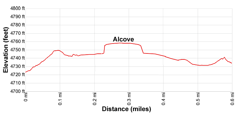
Distance: 0.6 miles
Coconino National Forest, near Sedona in Arizona's Red Rock Country
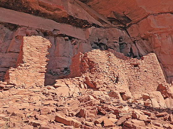
Cliff dwellings at Honanki
A short walk at the Honanki Heritage Site leads to interesting cliff dwellings and rock art along the base of Loy Butte. The site, occupied by the Sinagua people, is one of the largest in the area and definitely worth a visit. The road to the site is rough and requires good clearance.
- Distance: 0.6 miles (Loop)
- Elevation: 4,720-ft. at Trailhead
Maximum elevation - 4,768-ft. - Elevation Gain: 48-ft.
- Difficulty: easy
- Basecamp: Sedona
- Region: Arizona's Red Rock Country
Trail Description - Honanki Heritage Site
Honanki is a well preserved collection of cliff dwellings and rock art located in a remote canyon north of Sedona. The site, estimated to contain about 72 rooms, is one of the largest cliff dwellings in the area and was home to about 200 people.
Archeologists believe the site was occupied between AD 1150 to 1350. The Sinagua people, ancestors of the Hopi, were the first to live at Honanki. Later it is believed that the site was used by the Yavapai and Apache people. Palatki, a nearby site, was occupied during the same period and is also open to the public (reservations required).
The two sites were first visit in 1895 by Walter Fewkes, a famous turn-of-the century archaeologist from the Smithsonian Institution. He is credited with giving Honanki (Bear House) and Palatki (Red House) their Hopi names. The Hopi, however, have no specific names for these sites.
The Honanki site is accessed along a 0.6 mile self-guided loop trail. Interpretive signs provide information about the pueblo structures and how the people lived. A short, rocky climb is required to enter the area beneath the main cliff dwellings.
The loop trail starts at a visitor information booth to the north of the parking area. (See driving directions below.) A forest service employee or volunteer provides a brief orientation before you start the tour. About 100-ft. beyond the booth reach a junction and take the trail to the left to walk in a clock-wise direction. The trail on the right is the return leg of the loop.
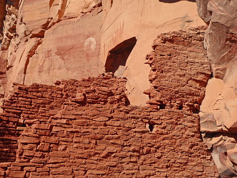
The easy trail heads north, traveling through bushes, pinyons and juniper trees toward Loy Butte. At 0.25 miles the path reaches a junction near the base of the cliffs. Turn left on the spur trail that climbs to a viewpoint beneath an alcove containing the first set of cliff dwellings. There is also rock art visible on the walls of the alcove.
Return to the junction when you are done viewing these ruins and then follow the loop trail right (southeast) along the cliff face. The path passes several sets of dwellings tucked under overhangs. Holes in the cliff face indicated that some of the dwellings were two stories high.
As you travel along the cliff face keep an eye out for pictographs and petroglyphs. Some of art is thought to date back as early as 5000 BC. One of the best pictographs is of a Kokopelli, a flute player.
When you are done viewing the ruins continue along the loop path that soon turns right (southwest) and heads back to the junction and information booth. The people manning the booth are happy to answer any questions you may have after visiting the ruins.
Note: Reservations are not required to visit Honanki. It is best to check when the site is open before setting out. When I last visited the site it was open from 9:30am to 3:00pm, 7 days a week. The site does close if it gets too hot. For more information check out the Honanki webpage or call the Red Rock Ranger District - 928-203-2900. A Red Rock Pass or the equivalent is required for parking. See the driving directions below for more information.
There is a vault toilet at the site but no water.
The road to Honanki is rough, especially the last few miles. A vehicle with good clearance is required. AWD or 4WD is helpful. Check on current road conditions before setting out. Those without the proper vehicle can see the site on a Pink Jeep Tour.
Elevation Profile
Driving Directions
Driving Directions from Sedona: From the traffic circle at the intersection of State Routes 89A and 179 head west on Arizona 89A for 9.6 miles and turn right onto Forest Road 525 / Loy Butte Road. The turn is just past mile marker 365. Follow Forest Road 525 for 9.5 miles. Just past the cattle guard at the Loy Canyon trailhead you will bear to the left to go around some private property. The site is on the right side of the road. Parking is on the left (south) side of the road.
Alternatively, those with high-clearance vehicles and/or a sense of adventure can turn right on Dry Creek Road off 89A and follow the signs for Enchantment Resort/Loy Butte. At the road to the Enchantment Resort, turn left onto Boynton Pass Road (FR 152C), and follow the signs for Loy Butte/Palatki (FR 525 to FR 795, pass FR 795 and continue up 525 for 2.5 miles to Honanki). This road is generally passable to passenger cars when dry, but it is not regularly maintained by the County and has some rough and rocky stretches. The compensation for driving the rougher road are wonderful views of Sedona’s red rock formations.
Note: a Red Rock Pass, America the Beautiful Interagency Pass, Golden Age Pass or Golden Access Pass is required to park in the lot. Red Rock Daily passes are $5, weekly passes are $15 and annual passes are $20. There is a machine at the site to purchase the pass. Passes can also be purchased in many shops around Sedona or online.
Trail Resources
- Trail Photo Gallery
- Trail Maps
- Basecamp(s) Information: Sedona
- Region Information: Arizona's Red Rock Country
- Other Hiking Regions in: Arizona