Soldier Pass 
Distance: 4.4 - 6.7 miles
Red Rock Secret Mountain Wilderness, Coconino National Forest, near Sedona in Arizona's Red Rock Country
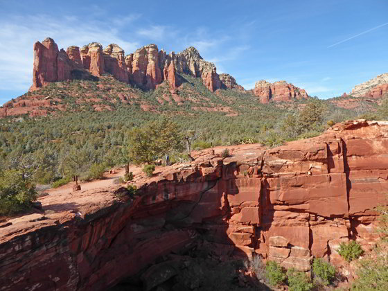
View from Devils Kitchen
This popular trail visits the Devils Kitchen, the Seven Sacred Pools and Soldier Pass Cave before climbing to the head of the Soldier Pass Canyon and Brins Mesa. From the mesa views stretch east to Wilson Mountain and north to the formations towering above the upper Dry Creek Valley.
- Distance: 4.4 - 6.7 miles (RT)
- Elevation: 4,440-ft. at Trailhead
Maximum elevation - 4,950-ft. - Elevation Gain: 510-ft.
- Difficulty: moderate
- Basecamp: Sedona
- Region: Arizona's Red Rock Country
Trail Description - Soldier Pass
Note: A Jeep Road travels up the west side of Solder Pass Canyon to a parking area near the wilderness boundary, a short distance from the junction with the spur trail to Soldier Pass Arches and Cave. Permits are required to drive the road. Tour operators use the rugged 4x4 road to take visitors to the Devil’s Kitchen and the Seven Sacred Pools. A few of the tours include the Soldiers Pass Arches and Cave.
Starting from the Soldier Pass Trailhead
The Soldier Pass trail starts at the northeast end of the trailhead parking area (See Driving Directions below). The path descends northeast through bushes and junipers, crosses a wash and then ascends on moderate grades to a junction with the Jordan Trail at 0.2 miles. Turn left at the junction on the continuation of the Soldier Pass trail.
Starting from the Jordan / Jim Thompson Trailhead
The Jordan/Jim Thompson trailhead offers an alternative route to the Soldier Pass Trail. While longer, the parking at the Jordan trailhead is much easier. (See the Driving Directions below). The trail begins near a kiosk along the west side of the parking area. Before setting off enjoy the great views of the Fin, the Acropolis and Tisha Spire rising above the east side of Mormon Canyon.
A short walk west along the path quickly leads to a trail junction. To the right is the Brins Mesa Trail. We bear left on the Cibola Trail. The path ascends through trees and brush on moderate to moderately steep grades up the ridge separating Mormon and Soldier Pass Canyon. Behind you openings offer more great views of the formations rimming the east side of Mormon Canyon.
Reach the top of the ridge at 0.35 miles. The Cibola Mitten and the Sphinx rise to the northwest. Coffee Pot Rock, Peak 5977 and Capitol Butte fill the skyline to the west. Behind you are fine views of Wilson Mountain, the Fin, the Acropolis, Tisha Spire and Steamboat Rock towering above Mormon Canyon.
The trail now descends through brush and trees on moderate grades to a junction with the Jordan Trail at 0.7 miles. Continue straight ahead (west) on the Jordan Trail. The trees and bushes soon give way to open slickrock with stunning views of the Sphinx and the Cibola Mitten to the north/northwest. Coffee Pot Rock and Peak 5977 dominate the view to the west.
After walking about a mile the Jordan Trail reaches a junction with the Soldier Pass Trail. Turn right at the junction on the Soldier Pass trail.
The Soldier Pass Trail
(The mileage for the remainder of this description includes two numbers. The first is the mileage from the Soldier Pass Trailhead while the second is the mileage from the Jordan/Jim Thompson Trailhead.)
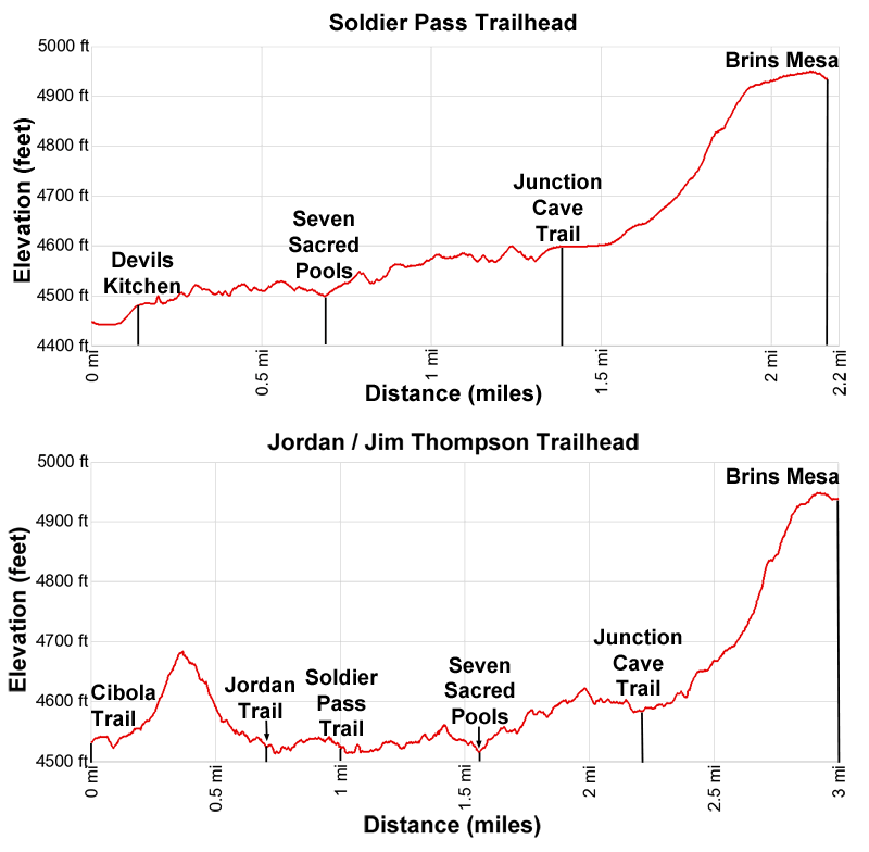
Immediately on the right is the Devil’s Kitchen, the largest sinkhole in the Sedona area measuring about 50-ft. deep and 150-ft. wide. The formations rimming the west side of Soldier Pass Canyon and beyond form the backdrop for this huge sinkhole that is expected to grow over time.
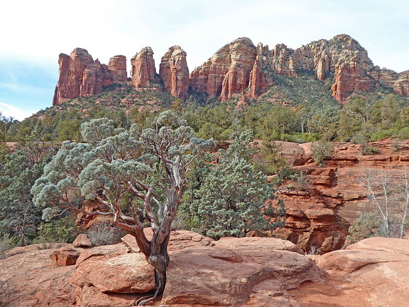
The undulating trail travels along slickrock and dirt, ascending on easy grades along the east side of the canyon. The Sphinx, a large fin, rises above the canyon to the east while the photogenic towers of Coffee Pot Rock and the rugged slopes of Peak 5977 rim the canyon to the west.
At 0.7/1.5 miles reach the Seven Sacred Pools. This series of small pot holes hold water even during dry periods. Peak 5977 and Coffee Pot Rock form the scenic backdrop for the pools. This is very popular spot along the trail, accessible from the Jeep Road that travels up the west side of the canyon.
The ascent continues on easy grades with more great views of the formations to the west. After 1.0/1.8 miles trees start appearing along the trail, partially blocking some of the views. After a tenth of a mile the path descends toward the canyon floor. At 1.3/2.1 miles pass a sign for the Soldier Pass trail. To the left is a path to a parking area at the end of the Jeep Road.
The path now resumes its ascent on easy grades, reaching an unmarked junction with a trail branching right at 1.4/2.2 miles. This is the trail to the Soldier Pass Arches and Cave. (There is a brown and while “National Forest Wilderness” sign nailed to a tress along the right side of the spur trail.) A short distance beyond the junction along the Soldier Pass trail is a large Red Rock – Secret Mountain Wilderness sign, marking the boundary of the wilderness area. If you reach this sign you have missed the trail to the cave.
Soldier Pass Arch and Cave
( (Note: The mileage to the cave is not included in the mileage for the Soldier Pass hike.)
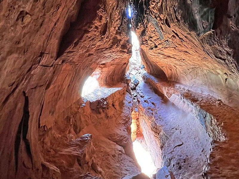
The Soldier Pass Cave is a very popular site in Sedona. Don’t expect solitude. The trail to the arches and cave is steep and rocky. The final ascent into the cave requires scrambling up a steep, rocky slope that is much easier to get up than down. (Many people will not be comfortable climbing into the cave.)
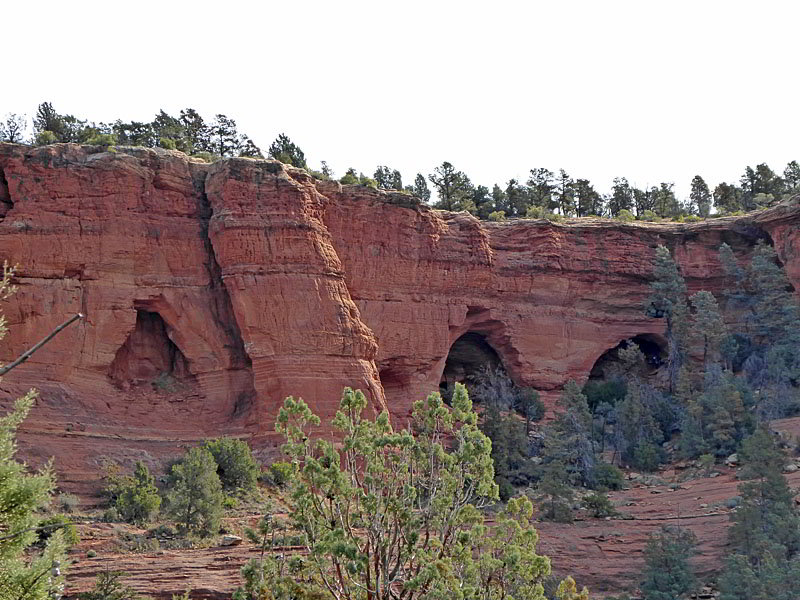
To visit the arches and cave turn right at the unmarked junction and follow the boot beaten path through trees, bushes and cacti. Soon you will reach an open expanse of slickrock. Stay to your left as you ascend the slickrock to find the continuation of the dirt path that now climbs very steeply up a rocky trail with some exposure. Reach the base of the cliff after 0.35 miles from the junction. Here there are three arches. The entrance to the cave that everyone wants to photograph is on the right.
To visit the interior of the cave you need to climb/scramble up a very steep rock slope. (Don’t be surprised to find a line of people waiting to enter the cave.) Openings in the cliff face light the red rock interior of the cave, creating opportunities for stunning photos.
The arches offer shady places to site with beautiful views of Capitol Butte and Peak 5977 to the east. When you are done visiting the site, descend carefully to the trail junction and turn right to continue up the Solider Pass Trail. Total round trip distance for this side trip is 0.7 miles.
To the Head of Soldier Pass Canyon and Brins Mesa
Beyond the junction for the cave and arches the ascent steepens and the trail becomes more rugged. As you gain elevation the trees give way to junipers, bushes and scrub. As you climb look east/southeast to see Soldier Pass Arches and Cave carved out of the red rock walls along the east side of the canyon. Multi-hued walls with distinctive formations rim the canyon to the west.
The moderately-steep ascent abates at 1.8/2.6 miles as the trail curves around a knoll. Turn around here for great views of Brins Butte, the Cibola Mitten and the Sphinx rising above the east side of the canyon. Peak 5977 and Coffee Pot Rock tower above the canyon to the west.
The moderately-steep ascent soon resumes, with the path now curving to the right as it crests Brins Mesa at 2.0 / 2.8 miles. Here the path curves to the right (northeast) and ascends on easy grades to the top of a low ridge with gorgeous views the formations towering above upper Dry Creek Valley to the north/northwest. Wilson Mountain and Lost Wilson Mountain rise above Brins Mesa to the east. The path now curves to the right (east) and descends on gentle grades to the junction with the Brins Mesa Trail at 2.2/3.0 miles.
Most people turn around at the Brins Mesa trail and walk back to the Soldier Pass Trailhead. Hikers looking for a long day can turn the trail into a loop. Beyond the junction the scenic Brins Mesa trail ascends across the mesa on easy grades. At the southern end of the mesa the path descends steeply into Mormon Canyon where it travels on easy grades to the Jordan / Jim Thompson Trailhead. From the Jordan/ Jim Thompson trailhead take Cibola and Jordan trails back to the Soldier Pass trail junction, 0.2 miles from the Soldier Pass trailhead parking area. See the Brins Mesa - Soldier Pass Trail for more information.
Elevation Profile
Driving Directions
The Soldier Pass parking lot, open from 8 a.m. to 6 p.m., only has space for 14 cars. Overflow parking is located 0.5 miles from the trailhead along the Soldier Pass Road. Signs clearly mark where no parking is allowed. Once past the signs you can park. Cars typically start lining up well before 8am in hopes of getting a space.
The Jordan trailhead is a much larger parking area without time constraints. I strongly recommend using the Jordan Trailhead for this hike. Instead of sitting in your car and waiting for a space you can be hiking. From the Jordan trailhead take the Cibola trail to the Jordan trail which leads to the Soldier Pass Trail. Total distance to the Soldier Pass trail is about 1.0 mile (one-way).
Driving Directions from Sedona to the Soldier Pass Trailhead: From the traffic circle at the intersection of Arizona 89A and 179 head west on Arizona 89A for 1.25 miles and then turn right onto Soldiers Pass Road. Drive 1.4 miles and turn right onto Shadow Rock Drive. Follow Shadow Rock Drive for 0.25 miles and then turn left onto Forest Road 9904. Follow FR 9904 for 0.25 miles to the parking area. (Note: Shadow Rock Drive will cross Rim Shadow Drive. FR 9904 is the first left after Rim Shadow Drive.)
The parking are only has room for 14 vehicles. Length restrictions apply. Overflow parking is located 0.5 miles from the trailhead along the Soldier Pass Road. Signs clearly mark where no parking is allowed. Once past the signs you can park.
Note: a Red Rock Pass, America the Beautiful Interagency Pass, Golden Age or Golden Access is required to park in the Soldier Pass lot. Red Rock Daily passes are $5, weekly passes are $15 and annual passes are $20. Passes can also be purchased in many shops around Sedona or online.
Driving Directions from Sedona to the Jordan (aka Jim Thompson) Trailhead: From the traffic circle at the intersection of Arizona 89A and 179 head north on Arizona 89A for 0.3 miles to a traffic circle. At the circle, take the third exit onto the Jordan Road. Follow the Jordan Road for 0.8 miles and then turn left onto West Park Ridge Drive. Drive 0.7 miles to the Jordan / Jim Thompson Trailhead at the end of the road. The road will be paved for the first 0.2 miles to a cul-de-sac. Drive through the cul-de-sac and then continue on a good dirt road to the trailhead. This lot does fill so get an early start.
Note: a Red Rock Pass, America the Beautiful Interagency Pass, Golden Age Pass or Golden Access Pass is required to park in the lot. Red Rock Daily passes are $5, weekly passes are $15 and annual passes are $20. There is a machine at the parking area to purchase the pass. The passes can also be purchased in many shops around Sedona or online.
Trail Resources
- Trail Photo Gallery
- Trail Maps
- Basecamp(s) Information: Sedona
- Region Information: Arizona's Red Rock Country
- Other Hiking Regions in: Arizona