West Fork of Oak Creek Canyon 
Distance: 2.0 - 7.2 miles
Red Rock Secret Mountain Wilderness, Coconino National Forest, near Sedona in Arizona's Red Rock Country
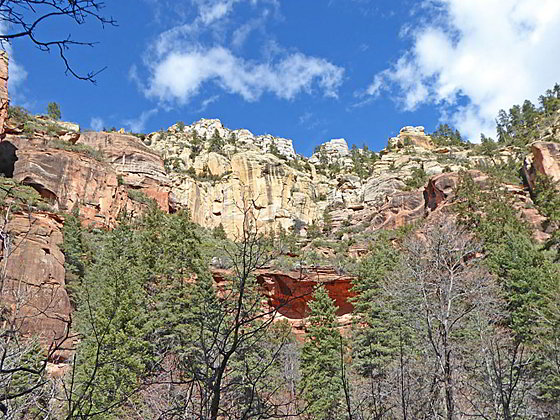
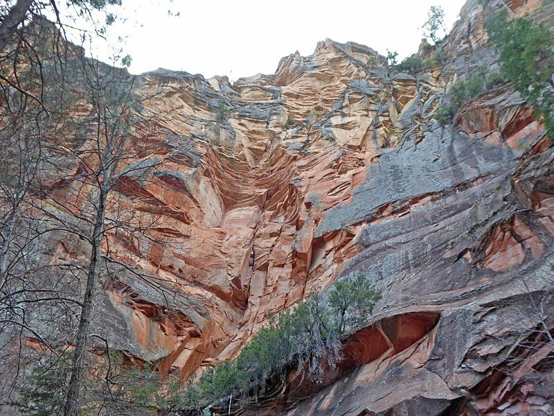
Beautiful canyon walls
This very popular trail, one of the top hikes in Sedona, travels up the West Fork of Oak Creek Canyon along a beautiful stream surrounded by lush vegetation. Dramatic, multi-hued canyon walls soar overhead.
- Distance: 2.0 - 7.2 miles (RT)
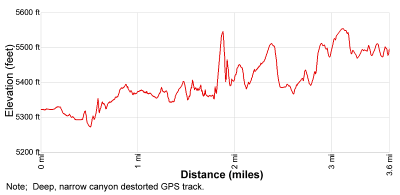
- Elevation: 5,270-ft. at Trailhead
Maximum elevation - 5,550-ft. - Elevation Gain: 280-ft.
- Difficulty: moderate
- Basecamp: Sedona
- Region: Arizona's Red Rock Country
Trail Description - West Fork of Oak Creek Canyon
While it is a tough call picking the best hikes in the Sedona Area, most people agree that the West Fork of Oak Creek is at or near the top of the list. It is truly a magical place. Around every corner and opening in the foliage are views to delight and surprise even the most jaded hiker.
The trail can easily be shortened. Walk as far as you like up the canyon and then turn around. The official distance for the trail is up to a forest service “Trail Ends” sign.
The trail up the West Fork of Oak Creek Canyon starts on the west side of the Call of the Canyon Day Use Area in Oak Creek Canyon. (See driving directions below.) Oak Creek Canyon is a gorge carved into the edge of the Mogollon Rim of the Colorado Plateau.
From the parking lot the trail heads west and crosses Oak Creek on a metal footbridge. Ahead are nice views of the steep slopes rimming the west side of Oak Creek Canyon. Beyond the bridge the broad trail turns left (southwest), travels through an orchard and then passes the ruins of the Mayhew Lodge. In its heyday the lodge was a favorite of movie stars, politicians and writers. The property was later sold to the forest service, which was planning on renovating the structure. Unfortunately the property burnt to the ground in 1980.
After 0.4 miles the trail curves to the right and enters the mouth of the West Fork of Oak Creek. Almost immediately you pass the boundary for the Red Rocks Secret Mountain Wilderness. Here you enter another world. Towering canyon walls, beautiful forest and a lovely stream will be your constant companions for the rest of the hike. The path gently weaves its way up canyon, crossing the creek 13 times to the end of the maintained trail. In places rocks and logs facilitate the crossings. At other crossings you may get your feet wet. Plan accordingly.
As you continue up canyon enjoy ever evolving views of the multi-hued canyon walls soaring above the trail. Spires, towers, knobs and fins top the formations extending into the canyon. Water sculpted overhangs, alcoves and eroded rock adorn the lower section of the canyon walls along the creek. Large boulders and slickrock benches along the creek bed offer resting spots to stop and take in the glorious views.
The lush canyon floor is filled with bushes, ferns and wildflowers, in season. Cottonwoods, oaks, maples, firs, pinyon pines and ponderosa pines form the beautiful canopy the helps keep hikers cool. In the autumn the canyon is ablaze with color.
In the winter and early spring the bare deciduous trees reveal vistas of the canyon walls not seen during other times of the year. Use caution during the colder months when ice and snow can cover the canyon floor and make creek crossings a challenge.
At 3.1 miles the trail steepens and the path becomes a bit more rugged. A sign at 3.6 miles marks the end of the maintained trail. Beyond this point the trail narrows into a slot and further travel requires walking in the creek. Check with the forest service personnel about current conditions if you intend to explore the unmaintained section of the trail. The path continues for 11 miles to the end of the canyon at Forest Road 531.
Don’t expect solitude along the trail. The West Fork of Oak Creek is popular, and deservedly so. Many people only walk a short distance up the canyon and then turn around. As such the numbers of people along the trail diminish the further you get from the trailhead.
Elevation Profile
Driving Directions
Driving Directions from Sedona: From the traffic circle at the intersection of Arizona State Roads 89A and 179 head northeast on Arizona 89A North for 10.6 miles and then turn left into the Call of the Canyon Day Use Area/West Fork Oak Creek trailhead. The turn is between mile posts 384 and 385. Fees apply and this parking lot fills early. In the event of snow, check with the Forest Service to be sure the parking area is open.
Trail Resources
- Trail Photo Gallery
- Trail Maps
- Basecamp(s) Information: Sedona
- Region Information: Arizona's Red Rock Country
- Other Hiking Regions in: Arizona