Blue Lake 
Distance: 6.0 miles (round trip)
Uncompahgre National Forest, near Telluride in Southwest Colorado
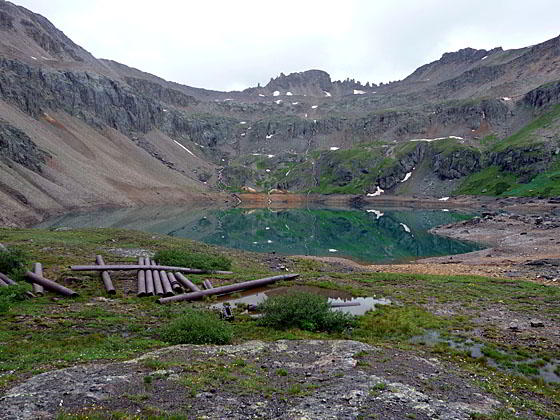
View of Blue Lake
This nice hike up pretty Bridal Veil Basin leads past waterfalls and wildflowers to Blue Lake (12,220-ft.) nestled in a glacial cirque littered with mining relics.
See Trail Detail/Full Description
- Distance: 6.0 miles (round trip) to Blue Lake
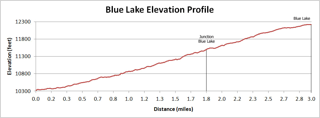
- Elevation: 10,400-ft. at Trailhead
12,220-ft. at Blue Lake - Elevation Gain: 1,820-ft. to Blue Lake
- Difficulty: moderate-strenuous
- More Hikes in:
Telluride / Southwest Colorado
Why Hike Blue Lake
Wildflowers and waterfalls abound on this pretty walk up Bridal Veil Basin to a large alpine lake set in a stark glacial cirque at 12,220-ft. Along the way the trail passes historic mining structures including the remains of an old tram, mining cabins and a bunkhouse. More mining debris is scattered around the lake.
Getting to the start of this hike is its own adventure. The 4WD road leading to the trailhead switchbacks up the headwall of Telluride’s box canyon, providing terrific views of Telluride, Bridal Veil Falls -- Colorado’s longest freefalling waterfall, and the historic power plant atop the falls.
Elevation Profile
| Buy the BookThis opinionated guide includes all the hikes in the Ouray, Telluride, Silverton and Lake City sections of the website plus info on local services and nearby attractions. |
Trail Resources
Trail Detail/Full Description / Trail Photo Gallery / Trail Map
Basecamp(s) Information:
Telluride
Region Information:
Southwest Colorado
Other Hiking Regions in:
Colorado