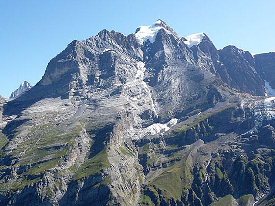
The Jungfrau from Tanzbodeli
The best hike in Lauterbrunnen climbs steeply to Tanzbodeli, an overlook atop a grassy plateau with jaw-dropping, panoramic views of the high peaks towering above the Lauterbrunnen and Sefinen Valleys. The return via Obersteinberg is packed with visual delights.
See Trail Detail/Full Description
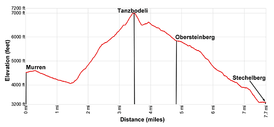
- Distance: 3.5 miles (one way) to Tanzbodeli
7.7 miles (one way) to Stechelberg - Elevation: 4,480-ft. at Trailhead
7,000-ft. at Tanzbodeli
2,985-ft. at Stechelberg - Elevation Gain: 2,930-ft. to Tanzbodeli
-4,015-ft. to Stechelberg - Difficulty: strenuous
- More Hikes in:
Lauterbrunnen / The Bernese Oberland
Why Hike Tanzbodeli
This is my favorite hike in Lauterbrunnen with incredible views of the Bernese Alps. The steep trail climbs to Tanzbodeli, "the dance floor", a high grassy plateau on the ridge between the Sefinen and Lauterbrunnen valleys with magnificent, 360-degree views.
Directly across from the plateau the Jungfrau, Gletscherhorn, Abeni Flue and Mittaghorn soar above the east side of the Lauterbrunnen Valley. At the head of the valley a beautiful glacial cirque, formed by the Grosshorn, Breithorn, Tschingelhorn and Ellstabhorn, creates the perfect backdrop for Schmadribachfall (waterfall) plunging down the lip of a hanging valley. To the west/northwest the peaks surrounding the Sefinen Valley, including the Gspaltenhorn and Butlasse, dominate to the view while to the north views extend down the length of the Lauterbrunnen Valley. All around you glaciers, clinging to the flanks of the high peaks, glisten in the sun.
From Tanzbodeli a trail descending on a diagonal high above the Lauterbrunnen Valley, with terrific views of the high peaks, leads to the pretty alp at Obersteinberg. The alp’s circa-1880 hotel and restaurant enjoy stunning views of Schmadribachfall plunging 1,000-ft. to the valley floor and the glacial cirque at the head of the valley.
At Obersteinberg, an optional side trip leads to the Oberhornsee, a small lake, situated in the rocky meadows between the moraines of the Breithorn and Tschingelfirn glaciers.
Hikers are presented with two options on the final leg of the hike from Obersteinberg to Stechelberg; a high route and a valley route. The high route is slightly shorter and features more great views of the high peaks before descending steeply through forest. The valley route enjoys fine views of the waterfall as it descends steeply to the valley floor and then wanders down valley beside the Weisse Lutschine River. Both trails end at the Hotel Stechelberg where regularly scheduled buses return to Lauterbrunnen.
This is a strenuous hike that will take longer than the mileage may imply. Pick a day that promises good weather and get an early start so you can enjoy the hike at a leisurely pace and have plenty of time to soak in the views from Tanzbodeli and Obersteinberg.
Elevation Profile
| Support our Site |
Trail Resources
Trail Detail/Full Description / Trail Photo Gallery / Trail Map
Basecamp(s) Information:
Lauterbrunnen
Region Information:
The Bernese Oberland
Other Hiking Regions in:
Switzerland