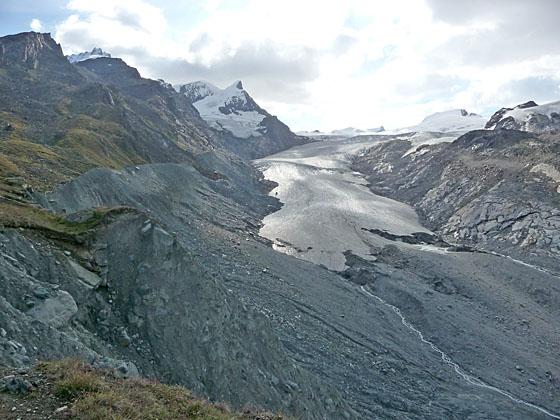
View of the Findel glacier from the top of the moraine
This moderately-easy trail leads to a peaceful overlook with wonderful views of the Findel Glacier flowing down the slopes of the Cima di Jazzi. Along the way hikers enjoy splendid views of the Matterhorn.
See Trail Detail/Full Description
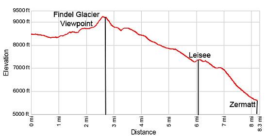
- Distance: 2.7 miles (one way) to Findel Glacier Viewpoint
8.3 miles (round trip) to Zermatt - Elevation: 8,457-ft. at Trailhead
9,217-ft. at Findel Glacier Viewpoint
5,490-ft. at Zermatt - Elevation Gain: 892-ft. to Findel Glacier Viewpoint
-3,727-ft. to Zermatt - Difficulty: easy-moderate
- More Hikes in:
Zermatt / The Valais
Why Hike Findel Glacier Viewpoint
This hike leads to a lovely overlook with captivating views of the Findel Glacier, a massive river of ice spilling down the slopes Cima di Jazzi and Strahlhorn on the Swiss-Italian border. Terrific views of the iconic Matterhorn, to the west, are your constant companion during much of the moderately-easy hike.
The day starts by taking the funicular to Sunnegga followed by scenic gondola ride to Blauherd. Here the hike descends east through meadows to the Stellisee, a beautiful lake which perfectly reflects the Matterhorn on its mirror-like surface.
Beyond the Stellisee, the trail ascends rocky meadows beside the Findel Glacier's northern lateral moraine. Before reaching the viewpoint, side trails allow hikers to climb up and walk along the knife-edge crest of the moraine wall with great views of the Findel Glacier and the deep, rugged trench dug by the receding river of ice. A final steep haul leads to a grassy knoll overlooking the huge icefield flowing in motionless waves down the flanks of the Cima Di Jazzi to the valley floor. To the west the Matterhorn, Dent Blanche and Ober Gabelhorn massif dominate the skyline.
On a sunny day the overlook is a great spot for a picnic. Not many people travel this far up the valley so you are likely to experience a level of solitude not found at the other viewpoints around the Zermatt valley.
The area's good trail system allows hikers to return to Blauherd gondola or walk down to Sunnegga and catch the funicular back to Zermatt. Energetic parties looking for a longer day can follow one of several trails descending steeply through meadows and larch forests to Winkelmatten, a neighborhood at the south end of Zermatt.
Elevation Profile
| Support our Site |
Trail Resources
Trail Detail/Full Description / Trail Photo Gallery / Trail Map
Basecamp(s) Information:
Zermatt
Region Information:
The Valais
Other Hiking Regions in:
Switzerland