Little Horse 
Distance: 3.8 - 4.2 miles
Coconino National Forest, near Sedona in Arizona's Red Rock Country
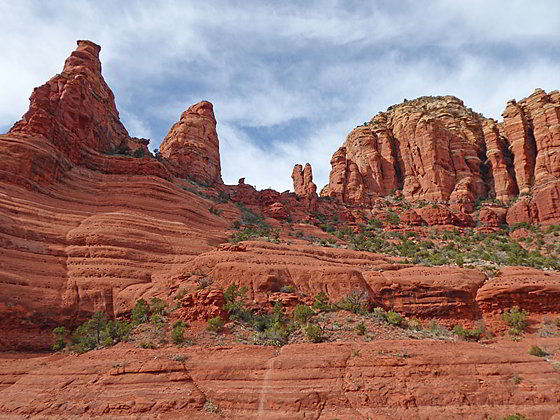
East Twin Butte and the Madonna, Child and Two Nuns Spires
This hike offers nonstop, panoramic views of some of the best red rock formations to the south of Sedona including Cathedral Rock, Courthouse Butte, Twin Buttes, the Madonna, Child and Two Nuns spires, Gibralter Rock, Submarine Rock, Munds Mountain and Lee Mountain.
- Distance: 3.8 - 4.2 miles (RT)
- Elevation: 4,281-ft. at Trailhead
Maximum elevation - 4,632-ft. - Elevation Gain: 351-ft.
- Difficulty: easy-moderate
- Basecamp: Sedona
- Region: Arizona's Red Rock Country
Trail Description - Little Horse
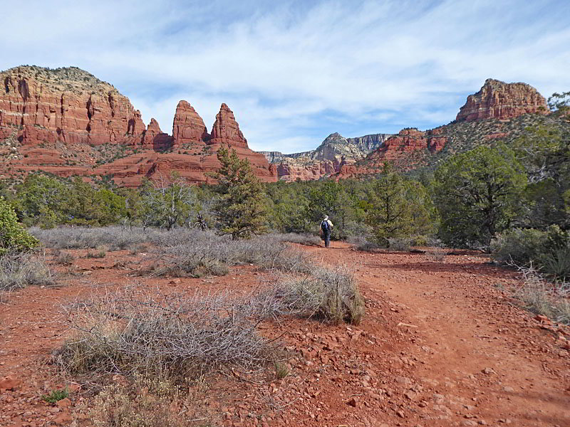
There are a lot of great hikes in Sedona but the Little Horse trail really delivers some big views in a short, relatively easy hike. Nonstop views encompass Cathedral Rock, Courthouse Butte, Twin Buttes, the Madonna, Child and Two Nuns spires, Gibralter Rock, Submarine Rock, Munds Mountain and Lee Mountain.
The trailhead for the Bell Rock Pathway to the Little Horse Trail is located on the east side of the Little Horse parking area. (See driving directions below.) From the parking area make an immediate right onto the Bell Rock Pathway toward the Little Horse Trail. The broad trail, shared by mountain bikes, descends gently southwest paralleling the highway. To the west are great views of Cathedral Rock. Gibralter Rock, East Twin Buttes and the Madonna, Child and Two Nun spires dominate the view to the east. Courthouse Butte rises to the south.
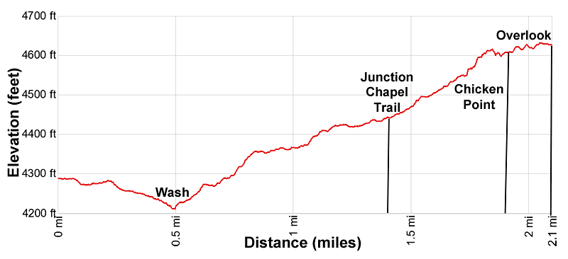
At 0.35 miles reach a junction and turn left (east) on the signed Little Horse Trail. The path soon descends to and crosses a wash, curving to the left (northeast). Beyond the wash the undulating path ascends on easy to moderate grades, traveling through scrub and trees with ever improving red rock views. Munds Mountain rises in the distance to the east.
At 1.1 miles the trail curves slightly to the right. East Twin Buttes and the Madonna, Child and Two Nuns spires tower overhead. Reach a junction with the Chapel Trail, branching left, beneath the base of the Two Nuns spires at 1.5 miles. The 0.6 miles (one-way) Chapel Trail heads northwest along the base of Twin Buttes to Chapel Road, a short distance from the Chapel of the Holy Cross.
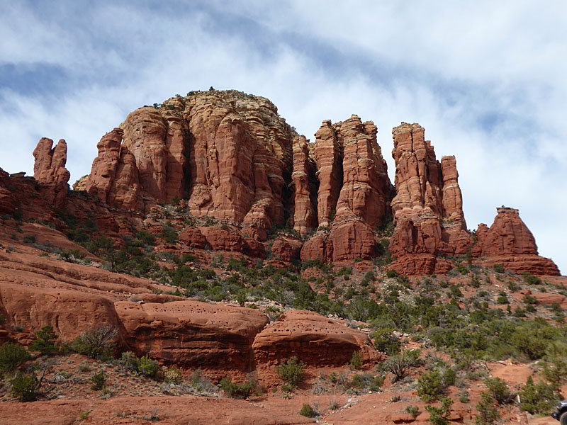
Bear right to stay on the Little Horse Trail, which now ascends on moderate grades up the brush clad slopes and slickrock benches beneath the south side of the Two Nuns. Gibralter Rock and nearby formations dominate the view to the south. As you gain elevation turnaround for great views of Cathedral Rock to the west.
At 1.75 miles the path curves left (north) as it starts a short, stiff climb up the south slopes of a knoll toward Chicken Point. Rock cairns mark the path as is ascends slickrock ledges. Rugged, multi-hued domes, spires and buttes rise above the trail.
Soon the path curves to the left, ascending the east facing flanks of the knoll. East Twin Buttes towers above the trail to the northwest. The Two Nuns loom over knoll to the west. Behind you, to the northeast, are stunning views of the sheer cliffs and rugged western slopes of Munds Mountain. Lee Mountain rises to the southeast.
The grade abates at 1.8 miles as you reach a large slickrock area atop the knoll known as Chicken Point (4,585-ft.). The point got its name from Jeep drivers daring each other to drive close to the edge. Nearby you will see a small area where Jeep operators park. (Chicken Point is a favorite destination on Jeep Tours along the Broken Arrow 4WD road. Thankfully vehicles are no long allowed out on Chicken Point.)
Walk across the slickrock to the southwest end of Chicken Point at 1.9 miles. Here enjoy close-up views of Twin Buttes and the Two Nuns. Gibralter Rock fills the skyline to the south. To the east are panoramic views of Munds and Lee Mountains. To the southwest views extend to the Seven Warriors formation across from Bell Rocks.
If time and energy allow I recommend continuing the hike northwest along the Broken Arrow trail to a second viewpoint along the east side of East Butte. The undulating path, open only to hikers and mountain bikes, ascends through scrub on easy grades to panoramic open slickrock overlook (4,632-ft.) at 2.1 miles.
Here views open north/northeast to the red rock towers and buttes rising above Marge’s Draw. The rugged cliffs and crags of Munds Mountain fill the skyline to the east. Submarine Rock, a low, elongated ridge of slickrock with two knolls, rises from a sea of scrub and trees along the valley floor. From this perspective it really looks like a Submarine.
When you are done taking in the views retrace your steps to the trailhead for a 3.8 to 4.2 miles walk, depending on your final stopping point.
Please keep in mind that there is little shade along this trail. Try to hike the trail during cool weather or early in the morning when it is hot. Make sure you take plenty of water.
The Bell, Little Horse and Broken Arrow trails are open to bikes. Keep an eye out for bikes on the trail and use caution when approaching blind corners. There are typically less bikes on the trail in the early morning and during week days.
Elevation Profile
Driving Directions
Driving Directions from Sedona to the Little Horse Trailhead: From the traffic circle at the intersection of Arizona 89A and 179 head south on Arizona 179 S for 3.6 miles and turn left into the Little Horse Trailhead. (You will go through 4 traffic circles along AZ 179 S before reaching the turn. The circular parking lot has one-way entrances, so watch for the directional signs when you turn. Overflow parking is available at the Yavapi Vista parking lot across the highway.
Note: a Red Rock Pass, America the Beautiful Interagency Pass, Golden Age or Golden Access is required to park in the lot. Red Rock Daily passes are $5, weekly passes are $15 and annual passes are $20. There is a machine at the parking area to purchase the pass. Passes can also be purchased in many shops around Sedona or online.
Trail Resources
- Trail Photo Gallery
- Trail Maps
- Basecamp(s) Information: Sedona
- Region Information: Arizona's Red Rock Country
- Other Hiking Regions in: Arizona