Long Canyon 
Distance: 7.2 - 8.4 miles
Red Rock Secret Mountain Wilderness, Coconino National Forest, near Sedona in Arizona's Red Rock Country
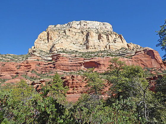
Peak 6510
Walk as far as you like along this beautiful trail that gently ascends forested Long Canyon with intermittent views of canyon’s red rock formations, sandstone cliffs and rugged summits. Solitude, silence, an interesting habitat and opportunities for exploration add to the allure of this hike.
- Distance: 7.2 - 8.4 miles (RT)
- Elevation: 4,515-ft. at Trailhead
Maximum elevation - 5,350-ft. - Elevation Gain: 835-ft.
- Difficulty: easy-moderate
- Basecamp: Sedona
- Region: Arizona's Red Rock Country
Trail Description - Long Canyon
Why Hike:
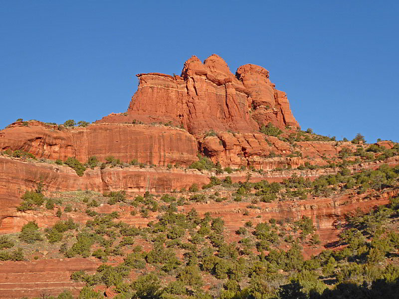
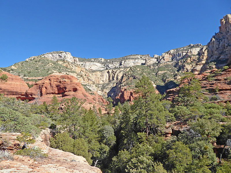
Quiet, peaceful and beautiful are words often used to describe the Long Canyon Trail. While this hike does not have big red rock views it does offer impressive vistas of the adjacent peaks, red rock formations and cliffs. It also offers an opportunity to escape the crowds.
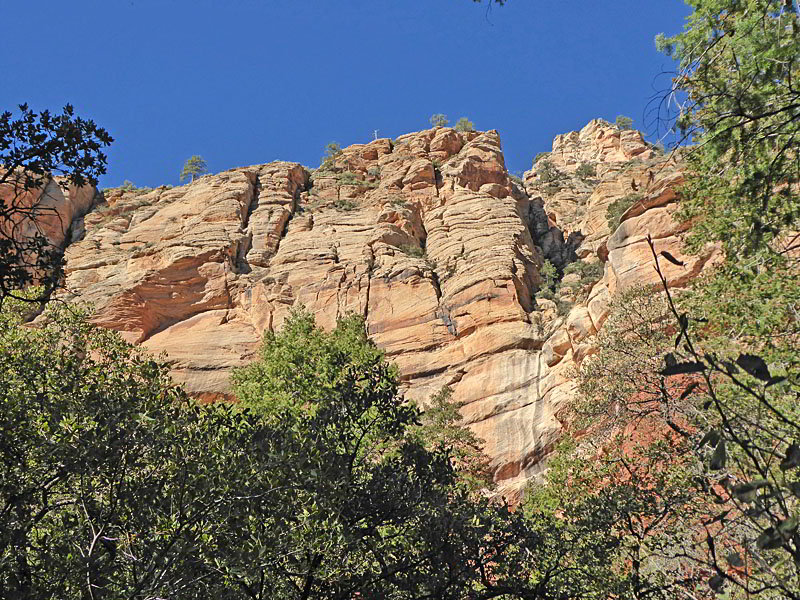
This trail initially travels through desert with fine views of nearby red rock formations. After a mile the path enters Long Canyon and the Red Rock Secret Mountain Wilderness. Here the vegetation thickens and the trail is soon ascending through beautiful forest. Openings offer intermittent views of the red rock fins, spires, knobs and towers along with the sandstone cliffs and rugged summits rimming the canyon. Gnarly trees, sculpted rock along the wash and wildflowers add interest to the hike.
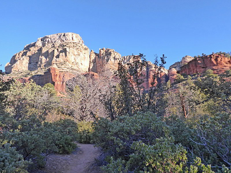
Two side trips provide opportunities for hikers to climb above the trees tops to scenic overlooks with great views of the surrounding formations. Both off-trail excursions require some route finding skills and the second, located at the end of the hike, involves a steep climb with some loose footing.
Be aware the peace of the canyon is occasionally interrupted by helicopter tours. The first 0.6 miles of the Long Canyon trail is shared with the trail to the Birthing Cave, a Sedona landmark that has become an Instagram sensation. Expect a crowded parking lot and many people along this initial segment of the trail.
Long Canyon Trail Description
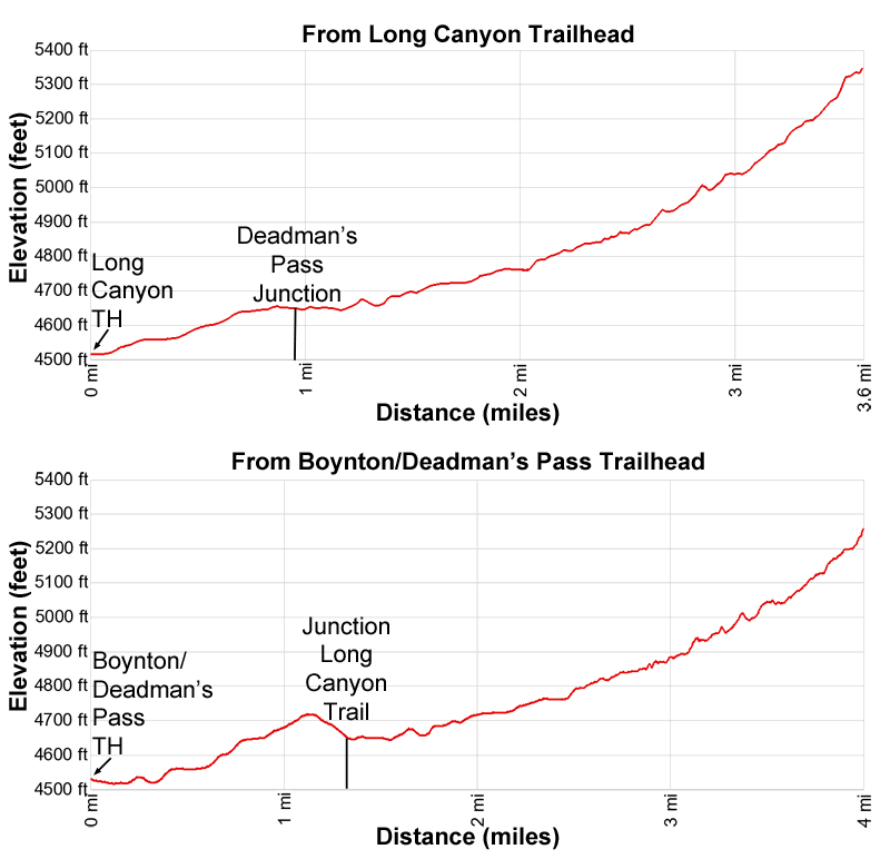
This trail can be started at the Long Canyon Trailhead or the Boynton Canyon/Deadman’s Pass Trailhead. I personally think the Deadman’s Pass trail is more scenic. Walk as far as you like up the canyon and then turn around. The official distance indicated below for the trail is up to a forest service “End of Trail” sign.
Trail distance -
From Long Canyon Trailhead (official end/with side trips): 7.2 / 7.6 miles RT
From Deadman’s Pass Trailhead (official end/with side trips): 7.9 / 8.4 miles RT
Long Canyon Trailhead to Junction with Deadman’s Pass
From the Long Canyon Trailhead (see driving directions below), the broad, sandy path heads northwest on easy grades through scrub oak, manzanita, yucca, junipers and pinyon pines. Soon views open to Mescal Mountain rising to the northwest. Ahead the summits of the peaks rising to the north are seen above the vegetation. To the east/southeast are fine views of Capitol Butte, Brins Mesa and Wilson Mesa.
At 0.4 miles the trail curves to the left on a segment skirting the western edge of a recently constructed golf course. Reach an unmarked junction at 0.6 miles. Ahead you will see the remains of a wood fence. Bear right at this junction to stay on the Long Canyon Trail. (The unmarked trail to the left leads to the Birthing Rock. At 0.95 miles reach a signed junction with the Deadman’s Pass Trail, branching to the left.
Note: There is little or no shade along this section of the trail. It is also open to mountain bikes.
Boynton Canyon/Deadman’s Pass Trailhead to the Long Canyon Trail
The Deadman’s Pass trail is located at the northwest end of the Boynton Canyon trailhead parking area across from the bathroom. (See trailhead directions below.) The path descends northeast on easy grades, accompanied by fine views of Mescal Mountain and the west wall of Boynton Canyon. Turn around for views of Bear Mountain rising above Fay Canyon, to the west.
At 0.1 miles pass a signed junction with the Boynton Canyon Trail, to the right. Continue straight ahead on the Deadman’s Pass Trail that now ascends on easy to moderately-easy grades. As you hike enjoy views of Mescal Mountain, rising to the east, and ever improving views of the Kachina Women and the sculpted southern flanks of Peak 5634 towering above the trail to the west.
At 0.4 miles pass the junction with the Mescal trail branching right. Soon views open left (northeast) to an amphitheater formed by Peak 5634 and Peak 6027. Views of the amphitheater improve as you continue up the trail.
The grade abates at 1.1 miles as the trail crests Deadman’s Pass. This high point enjoys fine views of the massive fin towering above the trail to the northwest. Ahead, Peak 6510 and the red rock formation rimming the northeast end of Long Canyon dominate the view. The path now descends on moderate grades to the end of the Deadman’s Pass Trail at the junction with Long Canyon trail at 1.3 miles. Turn left on the Long Canyon trail.
Note: There is little or no shade along this section of the trail. It is also open to mountain bikes.
Entering Long Canyon
(The mileage for the remainder of this description includes two numbers. The first is the mileage from the Long Canyon Trailhead. The second is the mileage from the Boynton/Deadman’s Pass Trailhead.)
A short distance past the Deadman’s Pass Junction, the trail enters the Red Rock Secret Mountain Wilderness and Long Canyon. Guarding the entrance to the canyon is the massive red rock fin extending from Peak 6027, to the west, and photogenic Peak 6510, to the east.
The path now ascends on easy grades along the west side of the canyon floor. As you ascend the canyon begins to narrow and trees, including Arizona cypress, pines, junipers and deciduous trees, now dominate. At 1.5/1.85 the trees thicken and start obstructing the views. Despite the thickening forest, openings in the trees afford great views of the rugged canyon walls, red rock formations and summits rimming both sides of the canyon.
As you head up canyon the trail crosses the dry creek bed several times. After the sixth crossing the trail passes a major side canyon branching right (north). At 2.75/3.1 miles, about a tenth of a mile beyond the sixth crossing, look for an unmarked trail to the right. This path leads to scenic viewpoint atop a red rock bench.
Side Trip to the Viewpoint
The trail to the viewpoint requires some route finding skills. To visit the viewpoint turn right at the unmarked junction on a trail that descends to and crossed the wash and then ascends moderately-steeply grades up bushy slopes along the east side of the canyon. Soon the narrow boot beaten path curves to the right and climbs a short, rocky trail to a narrow shelf and a junction.
Turn left at the junction and walk 100-ft. along the bench, watching for a path on the right climbing through vegetation to a slickrock bench with superb, unobstructed vistas. Here views extend northeast up the side canyon to Maroon Mountain. Peak 6520 towers above the side canyon to the east. To the north a large amphitheater ringed by red rock formation is seen along a ridge extending southwest from Maroon Peak. To the northwest views extend to the ridges rimming the upper end of Long Canyon. Peak 5848 rises across the canyon (south).
Take a break at the viewpoint to rest, eat lunch and simply enjoy the beautiful views. The area around the viewpoint invites exploration. You never know what you may find. Stay off of any crypto biotic soils you may encounter and avoid exposed, steep climbs that are outside of your comfort zone. Show respect and practice leave no trace principle. Return to the Long Canyon trail when you’re done enjoying the views. This side trip should add about 0.5 miles or more to the total trail mileage.
To the Official End of the Long Canyon Trail
As the trail progresses up canyon it becomes more rugged and the grades steepens. At 3.2/3.55 miles the path briefly ascends a little above the canyon floor and crosses a dry creek coming out of a minor drainage. At 3.4/3.75 miles a large fin appears straight ahead, dividing the canyon into two branches.
Our trail briefly climbs and then curves to the right as it enters the canyon’s north fork. (There is no trail up the northwest fork, to the left.) Here the undulating path steepens and the canyon constricts. Sheer walls soar above the canyon floor. The trees grow in stature, with Ponderosa pines and Douglas Firs dominating, and the vegetation thickens limiting views of the amazing walls.
At 3.6/3.95 miles reach a small sign just before a wash crossing that marks the end of the official trail. Most hikers are happy to turn around here and enjoying views of the canyon on the return trip to the trailhead.
Side Trip to the Upper Overlook
Hikers interested in exploring further should cross the wash and follow a boot beaten path climbing steeply/scrambling through trees and brush to the base of a crag. The path then skirts the base of the crag, passing a tiny arch. The final stiff climb is up steep slopes with loose rocks to an overlook above the tree tops. The overlook enjoys amazing views of the canyon’s sheer walls and wooded ravines. To the south (down canyon) partially obstructed vistas extend to the summits rimming the west side of the canyon.
Further explorations will uncover some surprises. Treat any places you discover with respect and follow leave no trace practices. When you are done exploring, carefully return to the canyon floor and hike back to the trailhead.
Elevation Profile
Driving Directions
Driving Directions from Sedona to Long Canyon Trailhead: From the traffic circle at the intersection of Arizona State Roads 89A and 179 head west on Arizona 89A South for 3.0 miles and then turn right (north) on Dry Creek Road. Follow Dry Creek Road for 2.0 miles to an intersection. Here Dry Creek Road turns right. We continue straight ahead on the Boynton Pass Road for 0.9 miles to and intersection and turn left onto Long Canyon Road. Follow Long Canyon Road for 0.6 miles to the Long Canyon Trailhead. Parking is on the left. You can also park along the sides of the road where there is sufficient room to get out of traffic. This is a popular area so get an early start.
Driving Directions from Sedona to Boynton Canyon Trailhead: From the traffic circle at the intersection of Arizona State Roads 89A and 179 head west on Arizona 89A South for 3.0 miles and then turn right (north) on Dry Creek Road. Follow Dry Creek Road for 2.0 miles to an intersection. Here Dry Creek Road turns right. We continue straight ahead on the Boynton Pass Road for 2.5 miles to and intersection and turn right onto Boynton Canyon Road. (The Boynton Pass Road continues to the left). Drive 0.1 miles on Boynton Canyon Road and then turn right (east) into the Boynton Canyon trailhead parking area.
The spur road to the parking area passes the trailhead, located across from the bathroom. Note: a Red Rock Pass, America the Beautiful Interagency Pass, Golden Age Pass or Golden Access Pass is required to park in the lot. Red Rock Daily passes are $5, weekly passes are $15 and annual passes are $20. There is a machine at the parking area to purchase the pass. The passes can be purchased in many shops around Sedona or online.
The Boynton trailhead parking lot fills early in the day. If the parking lot is full, overflow parking is available on the Boynton Pass Road, to the southwest of the intersection with the Boynton Canyon Road. (You will also need a pass to park here.)
Trail Resources
- Trail Photo Gallery
- Trail Maps
- Basecamp(s) Information: Sedona
- Region Information: Arizona's Red Rock Country
- Other Hiking Regions in: Arizona