Hoover Lakes 
Distance: 5.8 - 11.8 miles (round trip)
Hoover Lakes Wilderness Area, Humboldt-Toiyabe National Forest, near Lee Vining in California's Southeastern Sierra
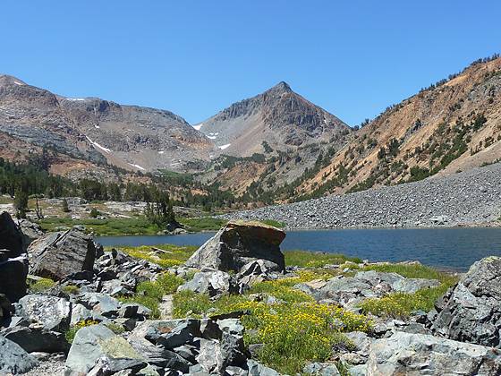
Multi-hued peaks form the backdrop of the Hoover Lakes, a pair of alpine jewels ringed by meadows and talus slopes. Along the way the trail traverses lovely meadows, climbs beside rushing streams and visits pretty Green Lake and beautiful East Lake.
See Trail Detail/Full Description
- Distance: 5.8 miles (round trip) to Green Lake
8.0 miles (round trip) to East Lake
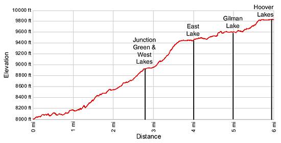
11.8 miles (round trip) to Hoover Lakes - Elevation: 7,990-ft. at Trailhead
8,945-ft. at Green Lake
9,458-ft. at East Lake
9,823-ft. at Hoover Lakes - Elevation Gain: 1,045-ft. to Green Lake
1,468-ft. to East Lake
1,833-ft. to Hoover Lakes - Difficulty: moderate-strenuous
- More Hikes in:
Lee Vining / Bridgeport / California's Southeastern Sierra
Why Hike Hoover Lakes
Glistening lakes, colorful peaks and lush meadows are a few of the scenic delights of this great hike up the West and East Forks of Green Creek. The trail begins by ascending the West Fork, passing forested Green Lake and photogenic East Lake along the way. Past East Lake the trail enters the East Fork drainage near Gilman Lake and then climbs steeply to the stunning Hoover Lakes basin.
There are enough destinations along the trail to suit the physical capabilities of a wide range of hikers and is a great choice for an easy backpack. Backpackers with the time and energy will want to climb beyond the Hoover Lakes to the aptly named Summit Lake, nestled in a saddle along the Pacific Crest. Past Summit Lake the trail drops into the backcountry of Yosemite National Park.
Elevation Profile

Trail Resources
Trail Detail/Full Description / Trail Photo Gallery / Trail Map
Basecamp(s) Information:
Lee Vining / Bridgeport
Region Information:
California's Southeastern Sierra
Other Hiking Regions in:
California
