Tamarack Lakes 
Distance: 9.6 miles (round trip)
John Muir Wilderness Area, Inyo National Forest, near Mammoth Lakes in California's Southeastern Sierra
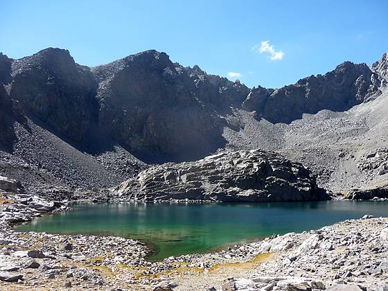
Tamarack Lake
The hike to Tamarack Lakes provides an opportunity to get off the beaten path in the popular Rock Creek drainage. The trail traverses a series of low ridges along the south side of a broad valley before climbing the East Fork of Rock Creek to a stark lakes basin in a rugged cirque.
See Trail Detail/Full Description
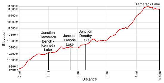
- Distance: 9.6 miles (round trip) to Tamarack Lakes
- Elevation: 9,743-ft. at Trailhead
11,605-ft. at Tamarack Lakes - Elevation Gain: 1,862-ft. to Tamarack Lakes
- Difficulty: moderate-strenuous
- More Hikes in:
Mammoth Lakes / Bishop / California's Southeastern Sierra
Why Hike Tamarack Lakes
Tamarack Lake (11,605-ft.) lies in a stark, barren basin framed by a cirque of serrated granite peaks and craggy ridges anchored by Broken Finger Peak (13,080-ft.). To reach the basin the trail climbs above the eastern shore of Rock Creek Lake, travels up a broad valley with access to a trio of lakes and then steeply ascends the scenic East Fork of Rock Creek valley to a high granite bench situated at the head of the Wheeler Ridge.
While not the most scenic trail in the Rock Creek valley it is certainly is the least traveled, offering a degree of solitude not found along the Little Lakes or Mono Pass trails. So if you are looking to get away from the crowds and get a good workout, lace up your boots and take a hike to the Tamarack Lakes.
Elevation Profile
Trail Resources
Trail Detail/Full Description / Trail Photo Gallery / Trail Map
Basecamp(s) Information:
Mammoth Lakes / Bishop
Region Information:
California's Southeastern Sierra
Other Hiking Regions in:
California