Les Houches to the Col de Tricot and Mont Vorassay 
Distance: 4.8 - 13.8 miles (round trip)
French Alps, near Chamonix in The French Alps
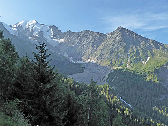
Bionnassay and the Bionnassay Glacier
This interesting hike features fine views of Bionnassay and its glacier and Mont Blanc and the southern end of the Aiguille Rouges along with distant views of the Fiz range to the north and the Aravis range to the west.
See Trail Detail/Full Description
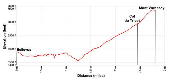
- Distance: 4.8 miles (round trip) to Col de Tricot
- Elevation: 5,890-ft. at Trailhead
6,955-ft. at Col de Tricot - Elevation Gain: 1,065-ft. to Col de Tricot
- Difficulty: moderate
- More Hikes in:
Chamonix / The French Alps
Why Hike Les Houches to the Col de Tricot and Mont Vorassay
This hike, either starting from Les Houches or at the top of the Bellevue Cable Car station, features great views of the Chamonix Valley, Dome du Gouter and Mont Blanc from the Bellevue ridge.
Beyond the ridge the Tour du Mont Blanc (TMB) variante (alternate) trail crosses beneath the Bionnassay Glacier and then ascends grassy slopes to the Col de Tricot, a high saddle between Mont Varassay and the Aiguille de Bionnassay. This segment features fine vistas of Bionnassay and the Bionassay Glacier and the Fiz Range. Atop the Col we get our first views of the Dome de Miages and it glaciers.
From the Col de Tricot, extend the hike with a side trip climbing to the top of the Mont Vorassay with panoramic views of Mont Joly and the peaks rimming the Val Montjoie, the Domes de Miage and Bionnassay and the Bionnassay Glacier. The detour, which takes 30 minutes, is well worth the effort.
Elevation Profile
Trail Resources
Trail Detail/Full Description / Trail Photo Gallery / Trail Map
Basecamp(s) Information:
Chamonix
Region Information:
The French Alps
Other Hiking Regions in:
France