Siyeh Bend to Sunrift Gorge 
Distance: 10.1 miles (one way)
Glacier National Park, near St Mary in Glacier Natl Park, MT
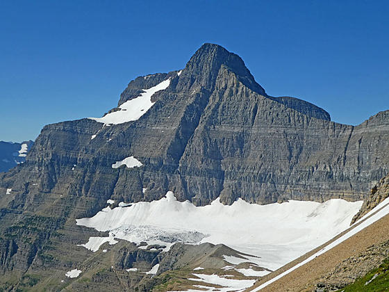
Going-to-the-Sun Mountain
Stunning views of Preston Park, the Baring-Boulder Divide and the Baring Creek Valley are the highlights of this great hike circumnavigating the Going-to-the-Sun Mountain and Matahpi Peak massif. The hike uses the Glacier shuttle bus to complete the loop.
See Trail Detail/Full Description
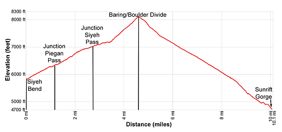
- Distance: 4.6 miles (one way) to Divide
5.5 miles (one way) to Sunrift Gorge - Elevation: 5,840-ft. at Trailhead
8,110-ft. at Divide
4,690-ft. at Sunrift Gorge - Elevation Gain: 2,270-ft. to Divide
-3,420-ft. to Sunrift Gorge - Difficulty: strenuous
- More Hikes in:
St Mary / Lake McDonald / Glacier Natl Park, MT
Why Hike Siyeh Bend to Sunrift Gorge
Breathtaking views of soaring peaks, glaciers, waterfalls and wildflowers are the rewards of this strenuous point-to-point trip circling Matahpi Peak and the Going-to-the-Sun Mountain. Starting at Siyeh Bend along the Going-to-the-Sun Road, the trail ascends through forest and then scenic Preston Park before climbing steeply to the divide separating the Baring and Boulder Creek valleys.
Views along this leg of the hike feature Piegan Mountain, Mount Siyeh, Matahpi Peaks and Reynolds Mountain. As you climb to the Divide vistas expand down the length of the Boulder Creek Valley. Cross the broad divide and stunning views open to Matahpi Peak and Going-to-the-Sun Mountain towering above the west side of the Baring Creek Valley. The Sexton Glacier lies nestled along a shelf beneath Matahpi’s east facing slopes. Little Chief Mountain dominates the views to the south.
The descent into the Baring Creek Valley is accompanied by ever improving views of the high peaks and Sexton Glacier. In season the slopes along the trail host spectacular wildflower displays. As you lose elevation views open to waterfalls pouring down the steep cliffs below the glacier. Near the foot of the valley the trail drops down to the valley floor and travels along Baring Creek.
The trail ends at the Sunrift Gorge trailhead area along the Going-to-the-Sun Road. Use the Park’s shuttle bus to return to your car at Siyeh Bend. Alternatively park at Sunrift Gorge and take the morning shuttle to the start of the hike. During the height of the summer season parking is very limited at the trailheads. It is best to leave your car at the St. Mary or Apgar Visitor Centers and use the shuttle bus. See the driving directions for more information.
Elevation Profile
Trail Resources
Trail Detail/Full Description / Trail Photo Gallery / Trail Map
Basecamp(s) Information:
St Mary / Lake McDonald
Region Information:
Glacier Natl Park, MT
Other Hiking Regions in:
Montana