Unterschachen to Hoch Fulen 
Distance: 9.6 - 12.0 miles (round trip)
near Altdorf in The Bernese Oberland
Schlossberg, Spannort and Kronton massifs
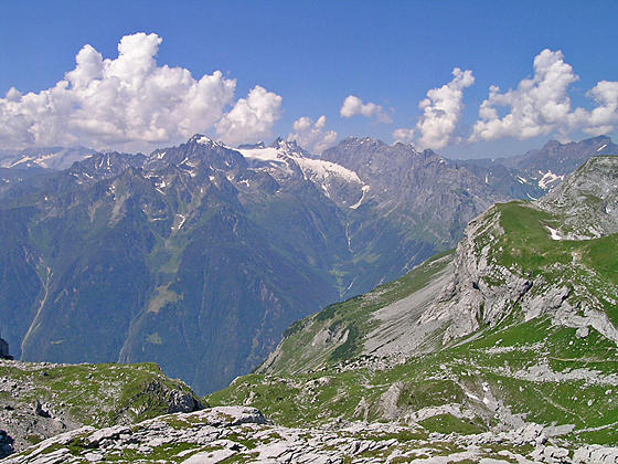
This long, challenging hike visits the lovely Brunnital and then ascends a wild, seldom visited valley to Hoch Fulen, a summit with stunning views of the Schachental Mountains, the Glarus Alps, including the Scharhorn, Clariden and Gross Windgallen, and the summits towering above the Reuss Valley to the west.
See Trail Detail/Full Description
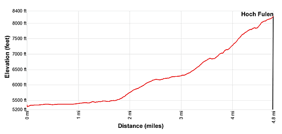
- Distance: 12.0 miles (round trip) to Hoch Fulen
- Elevation: 5,305-ft. at Trailhead
8,222-ft. at Hoch Fulen - Elevation Gain: 2,917-ft. to Hoch Fulen
- Difficulty: strenuous
- More Hikes in:
Altdorf / The Bernese Oberland
Why Hike Unterschachen to Hoch Fulen
Escape the crowds on this strenuous, off-the-beaten path hike climbing to the summit of Hoch Fulen, with breathtaking 360-degree views encompassing the peaks towering above the Schachen, Reuss and Brunni valleys. The hike starts with an easy walk up the Brunnital and then ascends the steep and wild Griess Valley to an airy ridge before the final stiff climb to the top of Hoch Fulen.
The hike, best done by fit, well acclimated hikers, starts with a 1.2 miles (one-way) walk from the Unterschachen bus stop to the Sittlisalp cable car that whisks hikers up 1,700-ft. to a high bench along the west side of the Brunnital. Sections of the hike are very steep, climbing up scree slopes and slabs. Combining the walk to and from the bus with the hike results in a 12.0 mile day with an elevation gain over 3,000-ft.
Before starting the hike check on the status and time table for the Sittlisalp cable car. Be sure to get an early start and pick a day full of promise so that you can enjoy the fabulous views from the summit of Hoch Fulen.
Elevation Profile
| Support our Site |

Trail Resources
Trail Detail/Full Description / Trail Photo Gallery / Trail Map
Basecamp(s) Information:
Altdorf
Region Information:
The Bernese Oberland
Other Hiking Regions in:
Switzerland