Griesalp to Kandersteg via the Hohturli Pass 
Distance: 9.1 miles (one way)
near Griesalp in The Bernese Oberland
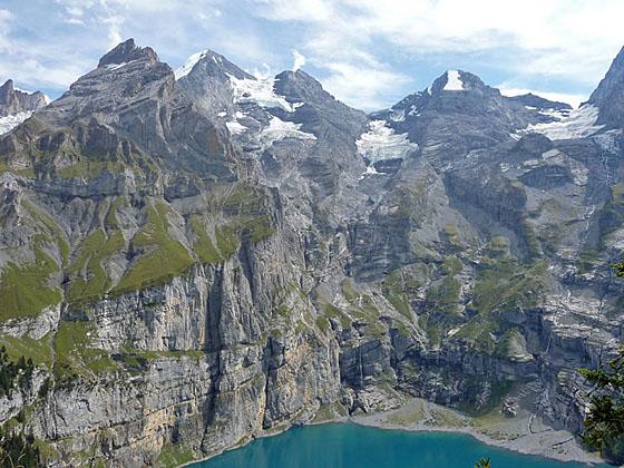
Amazing sheer walls along the flanks of the peaks ringing the Oeschinensee
The challenging hike over Hohturli Pass features captivating vistas of the high peaks towering above the Kiental and Kandertal valleys, front row seats to the dazzling Bluemlisalp Glacier and stunning views of the rugged cirque soaring above the Oeschinensee, one of the most beautiful lakes in Switzerland.
See Trail Detail/Full Description
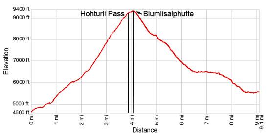
- Distance: 4.1 miles (one way) to Hohturli and Bluemlisalp Hut
9.1 miles (one way) to Kandersteg (Complete Hike) - Elevation: 4,630-ft. at Trailhead
9,350-ft. at Hohturli and Bluemlisalp Hut
5,530-ft. at Kandersteg (Complete Hike) - Elevation Gain: 4,720-ft. to Hohturli and Bluemlisalp Hut
-3,820-ft. to Kandersteg (Complete Hike) - Difficulty: strenuous-difficult
- More Hikes in:
Griesalp / Kandersteg / The Bernese Oberland
Why Hike Griesalp to Kandersteg via the Hohturli Pass
This very strenuous hike over Hohturli Pass, the highest pass on the Alpine Pass Route, features splendid views of the Kiental Valley, the glaciers spilling down the flanks of the Bluemlisalp massif and the Oeschinensee, a stunning lake surrounded by a dramatic cirque.
The hike starts with a steep climb through forests and pastures to Bundalp where the grade steepens as the trail ascends rocky meadows and then scree covered slopes along the southwest side of the Kiental Valley. Views extend from the peaks rising above the head of the valley to Lake Thun in the northwest. Wood steps, fix ropes and chains facilitate the final extremely steep climb to Hohturli Pass (9,114-ft.), where great views encompass the Kiental Valley, the Bluemlisalp glacier, the Oeschinen Valley and beyond.
At the pass take a detour to the Bluemlisalp Hut, perched atop a rocky knoll above the pass. Beyond the hut a use-trail leads to overlooks with wonderful, bird’s-eye views of the Bluemlisalp Glacier.
From the pass the trail to Kandersteg plummets down scree-covered slopes, descends along the crest of a moraine wall and then drops down to Ober Bergli, cradled in a lovely hanging valley high above the Oeschinensee. Views along this stage of the trail extend down the Oeschinen Valley to the high peaks rising above Kandersteg.
From Ober Bergli, a spectacular trail contours high above the north side of the breathtaking Oeschinensee with stunning views of the magnificent cirque of rugged peaks, draped with glaciers, towering above the lake’s aquamarine waters. Waterfalls, fed by glacial melt water, cascade down the cirque's sheer walls.
The final leg of the trail descends to the lovely meadows near a lift station where a gondola whisks tired but happy hikers down to Kandersteg.
This hike should only be attempted by well-conditioned, acclimated hikers. Do not start the hike during bad weather or if the weather looks threatening. The presence of snow and ice on the trail can turn this hike into a technical climb. Ask about current conditions at the guest houses and inns in Griesalp or talk to other hikers.
Elevation Profile
| Support our Site |
Trail Resources
Trail Detail/Full Description / Trail Photo Gallery / Trail Map
Basecamp(s) Information:
Griesalp / Kandersteg
Region Information:
The Bernese Oberland
Other Hiking Regions in:
Switzerland