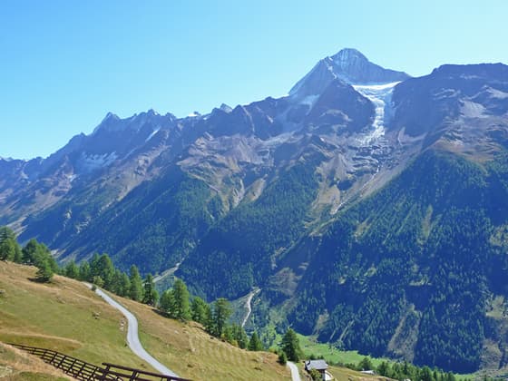
View of the Bietschhorn
This popular, easy segment of the Lötschentaler Höhenweg, a high route along the north side of the Lötschental (Lötschen Valley), travels through lovely meadows, beautiful larch forests and bucolic villages accompanied by panoramic views of the glacier-clad peaks rimming the valley.
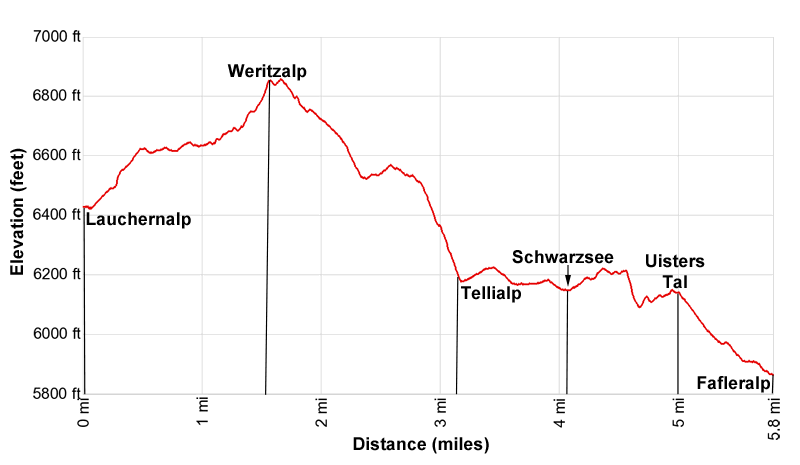
- Distance: 5.8 miles (RT)
- Elevation: 6,430-ft. at Trailhead
Maximum elevation - 6,856-ft. - Elevation Gain: 426-ft.
- Difficulty: moderate
- Basecamp: Kandersteg
- Region: The Bernese Oberland
Trail Description - Lauchenalp to Fafleralp
Note: There is a lot of up and down along this hike. The cumulative elevation gain and loss is +580-ft / -1,150-ft (+177-meters / -350-meters).
The path between Lauchernalp and Fafleralp is part the longer Lötschentaler Höhenweg, a 12.8 mile (20.6 km) trail following a high route along the north side of the Loetschental (Loetschen Valley) between Faldumalp and Fafleralp. The trail to the high route starts in Ferden and then climbs steeply to the beginning of the Höhenweg in Faldumalp, gaining over 2,100-ft. (640-meters) in 2.2 miles (3.5 km).
Due to the length of the trail and steep climb, many people divide the Höhenweg into two hikes; from Lauchernalp to Ferden and from Lauchernalp to Fafleralp. The Lauchernalp Bergbahn, a cable car, eliminates the climb to Lauchernalp.
The most popular and easiest section of the walk is from Lauchernalp to Fafleralp. The day starts in Wiler where hikers take the cable car to Lauchernalp. (See trailhead directions below.) At Lauchernalp exit the cable car station and find the trail signpost. Here signs point east (up valley) along a road toward the Lötschentaler Höhenweg to Weritzalp (50 min) and Fafleralp (2hr 30min) and west (down valley) for the for the Lötschentaler Höhenweg toward Hockenlp (15 min), Kummenalp (1h) and Faldumalp. We turn right (east) toward Weritzalp and Fafleralp
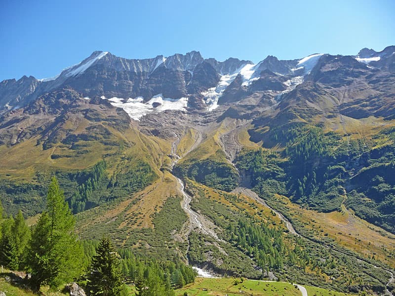
After a short stint along the road reach an intersection. Bear left (northeast) on Lauchernalp Strasse (street) to stay on the path toward Fafleralp. The road ascends on moderate grades through the village with fine views stretching up the Lötschental to the Sattelhorn and Mittaghorn towering above the head of the valley. The Lang and Anun glaciers spill down the slopes beneath the peaks. The Schinhorn, Lonzahoner, Lötschentaler Breithorn and Bietschhorn rise along the ridge rimming the south side of the valley.
Reach a signed junction at 0.25 miles (0.4 km). Here we leave the road, bearing right (east) on a trail toward Weritzalp, Fafleralp and the Lötschentaler Höhenweg. Soon the path curves to the left and ascends through meadows.
At 0.5 miles the trail reaches a junction with the Lötschentaler Höhenweg. To the left the trail leads to Kummenalp. We bear right toward Fafleralp. Soon the path curves to the right and crosses a bridge over the Milibach, a stream draining the slopes beneath the Sackhorn.
Beyond the crossing the path follows an undulating course though pretty meadows along the north side of the Lötschental. As you hike, turn around for distant views of the Weisshorn, towering above the ridges to the south. The Bietschhorn and its glaciers dominate the view across the valley while the summits of the peaks rimming the north side of the valley are seen above the trail.
At 1.0 miles (1.6 km) the trail briefly joins a road at Biel and quickly reaches a junction. Bear right on the trail toward Weritzalp, Tellialp and Fafleralp, which drops below the road. The path now ascends through meadows with scattered trees accompanied by great views of the Bietschhorn anchoring the serrated ridge of peaks across the valley.
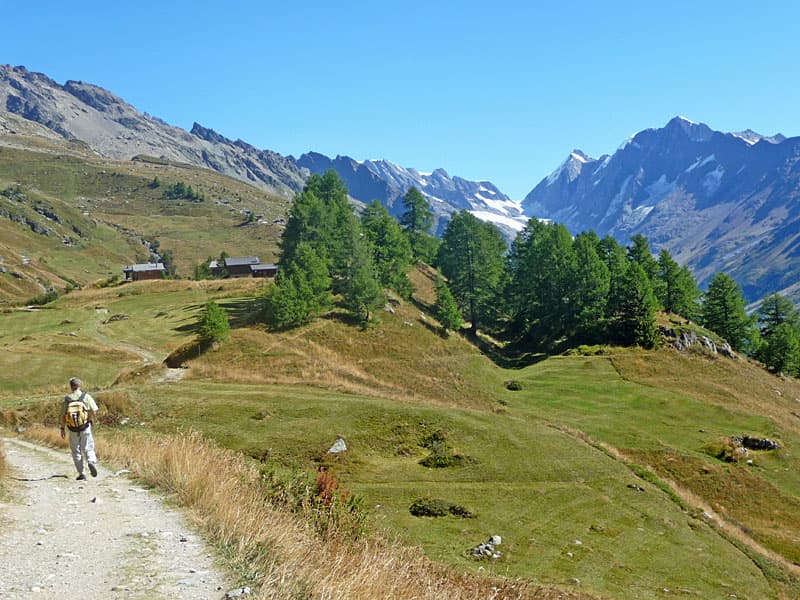
Reach Weritzalp and a junction at 1.5 miles (2.4 km). This is the high point of the hike at 6,886-ft. (2,099-meters). Here we bear right on the continuation of the Höhenweg toward Tellialp and Fafleralp. Be sure to turn around for good views of Lauchernalp and the peaks rising above the lower end of the Lötschental.
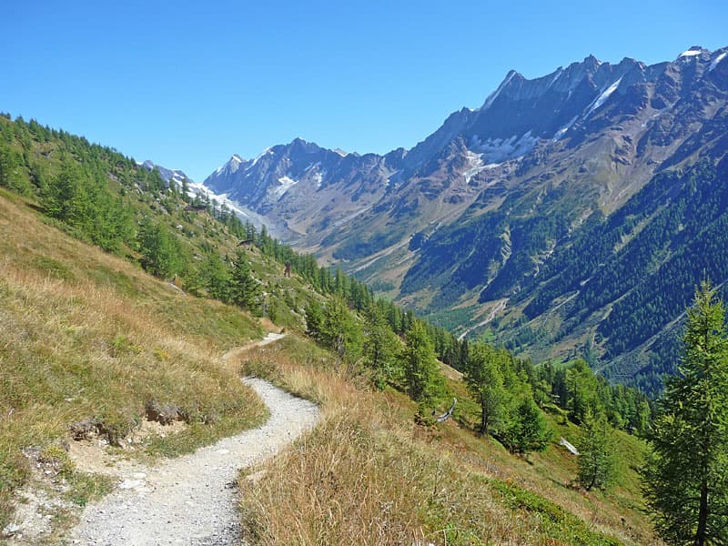
The path now descends on moderate to moderately-steep grades along steep slopes clad in meadows and trees, accompanied by fine views of the summits across the valley. At 2.1 miles (3.4 km) pass a junction with a trail dropping down to Blatten on the valley floor. We continue straight ahead toward Tellialp, the Schwarzsee and Fafleralp.
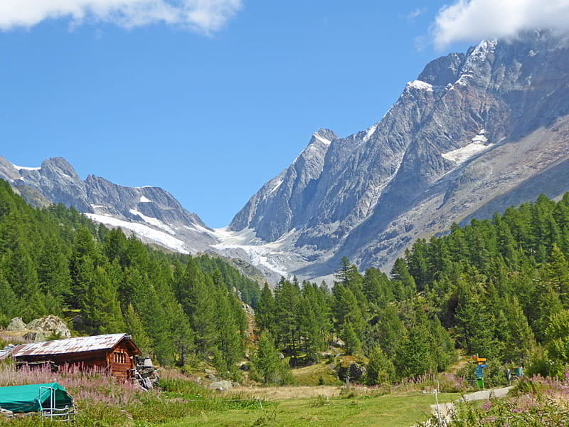
Past the junction the trail enters a pretty larch forest with intermittent meadows. Soon the grade abates and the path follows an undulating course through the trees. At 2.75 miles (4.4 km) the trail curves left into Im Tellin, a tributary valley, and then descends steep switchbacks to the valley floor. Openings along the way offers glimpses of the Tellingletscher (Tellin Glacier) and the Birghorn rising to the north.
At 3.2 miles (5.1 km) the path passes the tiny hamlet of Tellialp and then drops down to cross a bridge over the Gisentella, a raging torrent carrying meltwater from the Tellingletscher. The best views of the rugged ridge and glacier are seen from the pastures on east side of the Im Tellin after crossing the bridge.
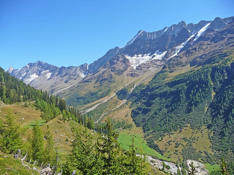
Soon the path exits the Im Tellin and follows an undulating course through larches and intermittent meadows along the north slopes of the Loetschental. Openings offer great views of the Bietschhorn, Lötschentaler Breithorn and the Lonzahoner
At 4.1 miles (8.0 km) the trail reaches the Schwarzsee, a pretty lake set amid rocky meadows and trees. A second smaller lake is located just to the east. The lake is a popular picnic spot and a good place to cool off on a hot day.
Past the lake the trail initially ascends and then descends through trees and meadows as it curves into the Uisters Tal, a tributary valley. Ahead views open to the Tellingletscher blanketing the rugged slopes high above the valley. Cross the Uistre Talbach, a stream carrying meltwater from the glacier, and then follow a broad track that exits the Uisters valley.
The path soon reaches the village of Fafleralp and a small pond at 5.0 miles (8.0 km). Continue past the village toward Fafleralp Parkplatz/Post Auto (parking lot). Soon views open to the Breithorn towering above the Inners Tal, another tributary valley. Cross a bridge over the stream draining the Inners Tal, travel through a campground and then reach the Fafleralp Park Platz, a large parking area.
The bus stop and the end of the hike is located at the east end of the parking lot at 5.4 miles (8.7 km). From the bus stop stunning views stretch up the upper Loetschental to the Lang and Anun glaciers spilling down the slopes beneath the Sattelhorn and Anuchnubel. If time and energy permit, I recommend extending the hike by 0.6 miles (1.0 km) (round trip) to a small knoll with panoramic views of the summits towering above the head of the valley. Otherwise, end the hike here and catch the bus heading down valley.
To extend the hike, continue up the valley along the broad gravel track toward the Grundsee. Soon the path reaches a bridge over the Lonza River. Turn right and cross the bridge, heading in the direction of the Grundsee. The path now climbs on easy grade 100-ft. up to the top of a low knoll at 6.1 miles. Some large rocks offer perches for taking in the views. When you done enjoying the vistas, retrace your steps back to the bus stop for a 6.4 mile (10.3 km) hike.
You can, of course, continue up the valley as far as you wish. I recommend coming back to the Loetschental another day and hiking the upper Lötschental valley from Fafleralp to Anenhutte, a 7.3 miles (11.4) loop trail leading to the Anen Hut. The entire day is filled with amazing views of the high peaks rimming the upper Loetschental Valley and the glacier-clad cirque at the head of the valley
Elevation Profile
Driving Directions
Note: The shortest and easiest access to this hike is to stay in the Lötschental (Lötschen Valley). The valley is also a fine day trip from many destinations along the main Valais train line from Sion or Brig. Thanks to the Lotschbergtunnel, this hike is also easily reached from Kandersteg in the Bernese Oberland.
From Wiler to Lauchernalp: Walk to the Talstation (Valley Station) for the Lauchernalp Bergbahn (cable car to Lauchernalp) and purchase a one-way ticket. The cable car runs every 30 minutes. Starting and ending times vary by season. Check the timetable on the Loetschental website for current information. The ride takes 5 minutes.
From Kandersteg (Bernese Oberland): From the Kandersteg Bahnhof take the train in the direction of Brig and get off at Goppenstein (about 13 minutes). Find the stairs that lead under the train tracks to the bus stop on the east side of the train station where you should board the bus bound for Fafleralp.
Get off the bus at the Wiler Talstation (Valley Station) for the Lauchernalp Bergbahn (cable car to Lauchernalp). The bus ride takes about 10 minutes. Purchase a one-way ticket. The cable car runs every 30 minutes. Starting and ending times vary by season. Check the timetable on the Loetschental website for current information. The ride takes 5 minutes. There are very good connections between the train and the bus in both directions. Train and bus schedule are available online on the SBB website and the SBB app.
Trail Resources
- Trail Photo Gallery
- Trail Maps
- Basecamp(s) Information: Kandersteg
- Region Information: The Bernese Oberland
- Other Hiking Regions in: Switzerland