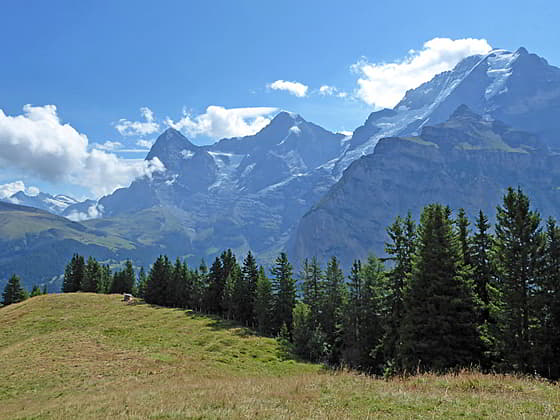
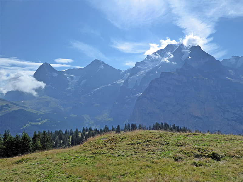
View of the Eiger, Monch and Jungfrau
The Mountain View Trail, from Grutschalp to Allmendhubel to Murren, features stunning views of the Eiger, Monch and Jungfrau along with the glacier-clad peaks rimming the cirque at the head of the Lauterbrunnen Valley.
- Distance: 3.5 - 5.0 miles (One Way)
- Elevation: 4,880-ft. at Trailhead
Maximum elevation - 6,230-ft. - Elevation Gain: 1,350-ft.
- Difficulty: moderate
- Basecamp: Lauterbrunnen
- Region: The Bernese Oberland
Trail Description - Mountain View Trail
Note: There is up and down along the trail. Cumulative elevation gain and loss for the trail is +1,700-ft./- 1,200 -ft (+518-meter/-366-meters).
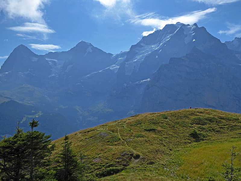
The Mountain View trail between Grutschalp and Murren travels through panoramic meadows with terrific views of a trio of iconic giants; the Eiger, Monch and Jungfrau, as well as nearby summits stretching from Schynige Platte in the north to the majestic cirque towering above the head of the Lauterbrunnen Valley in the south. During the height of the summer the trail passes through meadows awash in wildflowers and slopes scattered with flowering shrubs.
Grutschalp, located high above the Lauterbrunnen Valley, is a junction station on the Bergbahn Lauterbrunnen-Murren that links the cable car from Lauterbruunen with the rail line to Murren. In addition to the rail line two trails run between Grutschalp and Murren. The low route, paralleling the rail line, follows a broad, easy path through forest and intermittent meadows. The Mountain View trail, a more demanding option, rewards the extra effort required to ascend high above the rail line with stunning views.
Both hikes start by taking the cable car from Lauterbrunnen to Grutschalp (see trailhead directions below). After exiting the station at Grutschalp turn right and cross the train tracks. Continue straight ahead to a broad track. Turn left on the track and quickly reach a set of trail signs. Here signs point left (south) for both trails with the low route passing through Winteregg on its way to Murren (1h 15min) whiles the Mountain View Trail (#351) travels through Bletschenalp (1h) and Almmendhubel (2hr 30 min) to Murren (3hr 10 min).
Walk a short distance along the broad trail to a junction. Here the low route continues straight ahead (south) along the broad track. We turn right (southwest) on the Mountain View Trail #351 toward Allmendhubel and Murren. The trail now ascends steeply through meadows and clusters of trees. Openings offer ever improving views of the Eiger, Monch and Jungfrau to the southeast. The Mannlichen Ridge rises across the valley to the east. As you climb the trail skirts a small farm and then reaches a junction at 0.8 miles (1.3 km). Bear left to stay on the trail #351 toward Bletschenalp and Allmendhubel.
Soon the trail emerges from the trees and passes a second junction with a trail branching left toward Winteregg. Stay on the Mountain View Trail as it ascends on easy grades through meadows with fine views of the big three peaks. Joining the scene to the south of the Jungfrau are the Gletscherhorn, Abeni Flue and Mittaghorn, rimming the east side of the upper Lauterbrunnen Valley.
The worst of the climb is now over. Ahead you will see a saddle on a ridge. The trail ascends to the saddle but the climb is not nearly as steep.
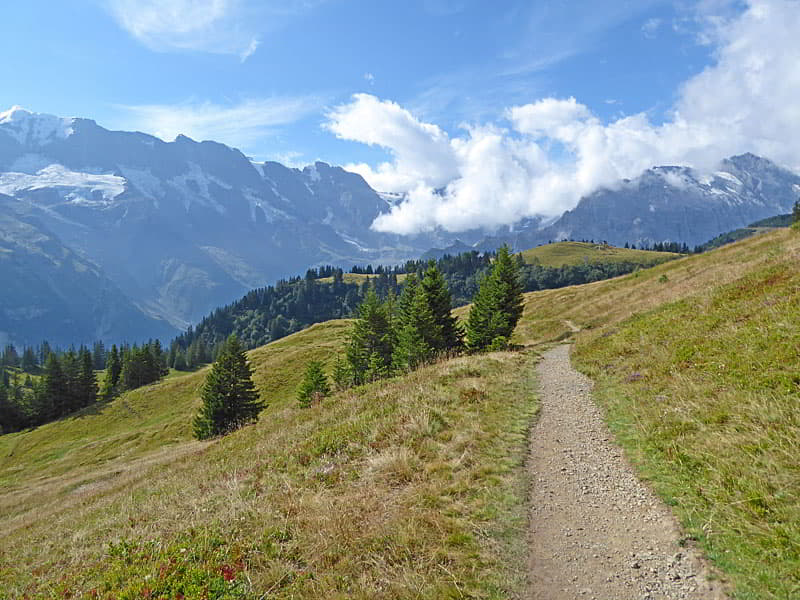
The path now follows an undulating course along meadows scattered with trees and low shrubs, crossing the Staubbach, a small stream, at 1.25 miles (2.0 km). Beyond the crossing the trail ascends on moderate to moderately steep grades through meadows and low shrubs to a broad, grassy saddle at 1.7 miles (2.7 km), just to the west of the Dorenhubel. Ahead the Eiger, Monch, Jungfrau, Gletscherhorn and Abeni Flue fill the skyline.
Wander across the saddle and then cross the Sissbach, a small stream. Below views open to some pistes for the ski lift between Winteregg and Almendhubel. The path now descends into a small bowl, passing a junction with a trail branching left toward Oberberg and Mittelberg. We continue straight ahead on the trail to Allemendhubel.
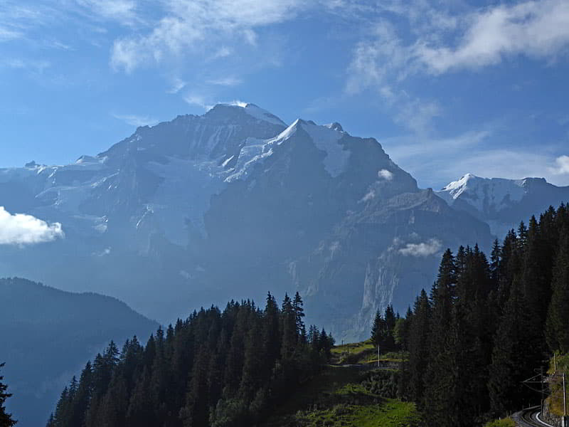
Follow the path as it ascends through meadows on easy to moderate grades. At 2.2 miles (3.5 km) the grade abates as the trail passes under the lift line. Along the way enjoy ever improving views of the big three along with the glacier-clad Gletscherhorn, Mittaghorn, Grosshorn, and Breithorn rimming the cirque at the head of the Lauterbrunnen valley. The Beitenhorn looms overhead to the west.
Beyond the lift line the trail curves around the slopes beneath the Maulerhubel and then descends to a gravel track at 2.5 miles (4 km). Turn right on the track toward Allmendhubel. Ahead views extend up the Lauterbrunnen valley to the Ellstabhorn and Gspalternhorn rising above the west side of the valley.
The track now descends to and crosses the Agertenbach, a stream. Look left (east) for views that extend across Kleine Scheidegg, a saddle on the Mannlichen Ridge, to the Wetterhorn and Mittelhorn in the Grindelwald Valley.
Past the crossing a short, steep climb leads to a junction at Hohlucke at 3.0 miles (4.8 km) where five trails converge at a somewhat confusing junction. Turn left on trail #351 toward Allmendhubel. The path now ascends to the Allmenhubel Flower Park. A pretty garden where signs identify the various plants. Past the garden the trail descends to the playground, restaurant, and funicular station at Allmendhubel at 3.25 miles (4.8 km). This scenic spot enjoys great views of the big three and the peaks rimming the Lautrebrunnen Valley. To the west the saddle at Kleine Scheidegg offers views of the Wetterhorn and Mittelhorn.
Here a decision needs to be made. You can end your hike here by taking the funicular down to Murren where a short walk leads to the train/cable car back to Lauterbrunnen. Alternatively, you can walk down to Murren. If time and energy permit I suggest walking back to Murren.
There are two options for the walk back to Murren with various shortcuts along the way. For all options walk to the front of the funicular station where a broad track curves to the south and then west, descending on moderate grades through trees and then meadows toward Murren. The trail is also marked for the Northface and Blumental (Flower) trail. At 3.5 miles (5.6 km) a trail branches left and descends steeply through meadows toward Murren. I prefer staying on the broad track where the easy walking allow me plenty of time to admire the great views of the Birg and the nearby peaks rising to the west, the glacier-clad summits rimming the cirque at the head of the Lauterbrunnen Valley and the farms dotting the pastures in the emerald green bowl below the trail to the south. Soon the trail curves to the left (south) and reaches an intersection at the Restaurant Hotel Sonnenberg at 3.9 miles (6.3 km). Turn left (east/southeast) at the junction, following the signs toward Murren. Note there are two signs for Murren both pointing in the same direction. One sign is for the path leading to the lift at the south end of Murren which descends to the Stechelberg in the Lauterbrunnen Valley and the other sign is for the trail heading to the train (Bergbahn Lauterbrunnen-Murren) at the north end of Murren.
A short distance beyond is a second junction. Here the two trails to Murren split with the Blumental (Flower trail) turning right and descending toward the lift to Stechelberg. Continuing straight ahead on the broad track leads to the train. Either trail works since once you reach the village it is easy to walk along the main street to either the cable car station or the train.
For the best views I recommend staying on the broad track that descends steeply, passing farms and houses set amid pastures to the center of the village. In the village turn left (north) along the main street, reaching the train station in 5.0 miles (8.0 km).
The flower trail also descends steeply, passing through pastures and forests as it drops down to the main street just above the lift descending to Stechelberg in 4.7 miles (7.6 km). There are several junctions along this route, simple choose the trails with signs pointing to the lift station. To reach the train (Bergbahn Lauterbrunnen-Murren) from the lift station head north along main street for 0.6 miles (1.0 km).
No matter which way you go enjoy the stroll through Murren, a charming, car free village with terrific views of the peaks towering above the Lauterbrunnen Valley. There are many restaurants and shops along the main street, in addition to a small, but well stock Coop supermarket.
When you are done exploring Murren, hop on the train that leads to the lift dropping down to Latuerbrunnen. The cable car down to Stechelberg is a good option for parties that wish to catch the bus back to Lauterbrunnen, stopping at Trummelbach Falls along the way.
Elevation Profile

Driving Directions
From Lauterbrunnen to Grutschalp: Across the street from the north end of the Lauterbrunnen Bahnhof (train station) find the Lauterbrunnen to Murren Bergbahn. Take the four-minute cable car ride to the top station at Grutschalp. (Only purchase a ticket for the cable car and not for the train that continues to Murren.) Check the SBB website and the SBB app for the current schedule.
From Murren to Lauterbrunnen: From the Murren train station at the north end of the village, take the train to the Murren Bergbahn, the cable car descending to Lauterbrunnen. The train ride takes 14 minutes and the cable car descending to Lauterbrunnen takes 4 mintues. The walk from the train to the cable car is short. You will not have any problems making the connection.
Alternatively, from the south end of Murren take the Schilthorn Cable Car (Schilthornbahn) to Stechelberg. You will need to change cars in Gimmelwald. At the bottom station for the Schilthornbahn catch the #141 bus bound for Lauterbrunnen. The ride to the Lauterbrunnen Bahnhof takes 14 minutes. There are many bus stops between the cable car station and the train station in Lauterbrunnen.
Check the SBB website and the SBB app for the current schedule and to the find the stop near your accommodation.
Trail Resources
- Trail Photo Gallery
- Trail Maps
- Basecamp(s) Information: Lauterbrunnen
- Region Information: The Bernese Oberland
- Other Hiking Regions in: Switzerland