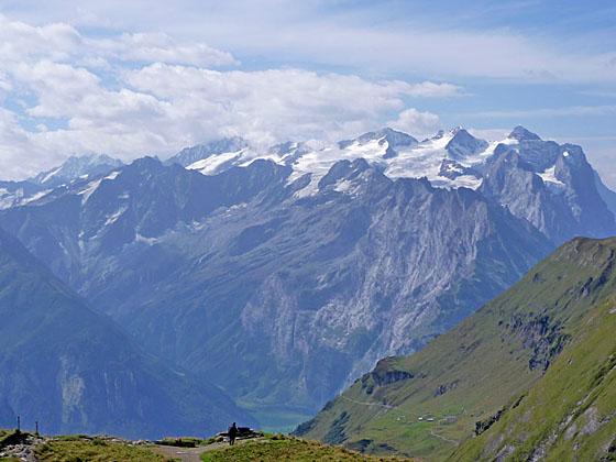
The Bernese Oberland peaks dominate the view to the southwest
The beautiful hike from Engstlenalp to Planplatten visits the scenic Tannersee, enjoys terrific views atop the Balmeregghorn and then travels to the overlook at Planplatten with panoramic vistas of the high peaks towering above four valleys.
See Trail Detail/Full Description
- Distance: 4.5 miles (one way) to Balmeregghorn
6.4 miles (one way) to Planplatten (Meiringen) - Elevation: 6,017-ft. at Trailhead
7,398-ft. at Balmeregghorn
7,365-ft. at Planplatten (Meiringen) - Elevation Gain: 1,382-ft. to Balmeregghorn
-567-ft. to Planplatten (Meiringen) - Difficulty: moderate-strenuous
- More Hikes in:
Meiringen / Engstlenalp / The Bernese Oberland
Why Hike Engstlenalp to Meiringen
This scenic hike with nonstop views follows the Alpine Pass route between Engstlenalp and Meiringen, traveling along the steep slopes and high ridges on the northwest side of the Gental Valley. Along the way the signature peaks of the Bernese Alps soaring above Reichenbach and Grindelwald Valleys dominate the view to the southwest. The Wendenstocke, Tallistock and the rugged intervening ridge fills the skyline across the Gental Valley while the Jochstock and Titlis rise to the east.
From Engstlenalp the trail climbs the Spycherflue to Tannalp. Here the Rothorn, Glogghus and Hochstollen, towering along the rugged ridge rimming the southwest side of the Melchsee Valley, form the perfect backdrop for the Tannersee, a pretty lake nestled in the pastures of Tannalp.
After skirting the southeast side of the Tannersee the trail climbs atop a ridge with impressive views in all directions. The trail now travels along the ridge crest, ascending to the Balmeregghorn with more splendid views. Here the Dammastock, rising above the glistening Trift Glacier on the south side of the Gadmertal Valley, joins the scene.
Beyond the Balmeregghorn the trail follows an undulating course along the rugged southeast flanks of the Rothorn and the Lauber and then traverses a ridge crest to the overlook at Planplatten. The overlook, at the convergence of four valleys, showcases an amazing panorama of the area’s peaks and glaciers.
From Planplatten a combination of gondolas and a cable car whisk hikers to Meiringen. Alternatively, take the trail from Planplatten to Reuti and then ride the cable car to Meiringen or walk the entire way to Meiringen.
Elevation Profile

| Support our Site |

Trail Resources
Trail Detail/Full Description / Trail Photo Gallery / Trail Map
Basecamp(s) Information:
Meiringen / Engstlenalp
Region Information:
The Bernese Oberland
Other Hiking Regions in:
Switzerland