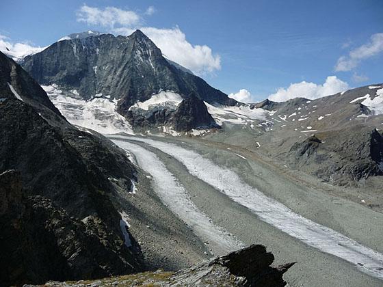
Mont Blanc de Chelion rising above a river of ice flowing down the Val des Dix
This beautiful trail, showcasing the peaks rising along the east and south sides of the Arolla Valley, leads to a pass on a rugged ridge with fine vistas of the Glacier de Cheilon flowing down the Val des Dix, Mont Blanc de Cheilon and Le Pleureur.
See Trail Detail/Full Description
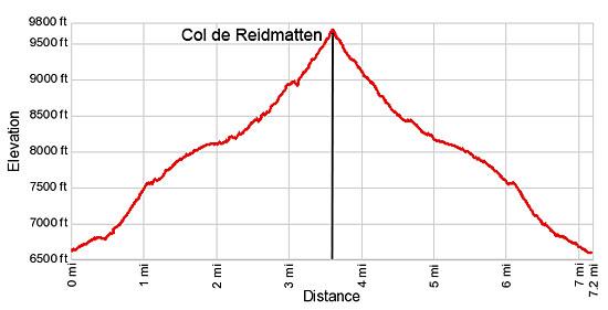
- Distance: 7.2 miles (round trip)
- Elevation: 6,602-ft. at Trailhead
Maximum elevation: 9,679-ft. - Elevation Gain: 3,077-ft.
- Difficulty: moderate-strenuous
- More Hikes in:
Les Hauderes / Arolla / The Valais
Why Hike Col de Riedmatten
The walk to the Col de Riedmatten is delightful, traveling through beautiful meadows with splendid views of the glaciers spilling down the slopes of the Pigne d'Arolla. To the east/southeast (behind you), the jagged peaks towering above the east side of the Arolla Valley, including Dent de Perroc, Pointe des Genevois and Aiguille de la Tsa, fill the skyline.
The pass, located on the rugged ridge separating the Val d'Arolla and Val des Dix, enjoys fine views of Mont Blanc de Cheilon rising above the Glacier de Cheilon, a river of ice flowing down the flanks of the peak. To the west, La Luette, Le Pleureur and Le Sale grace the skyline. To the southeast, Mont Collon and the Bouquetins massif dominate the view. On a clear day the top of the Matterhorn joins the scene.
The Col de Riedmatten is within 800-ft. of a second pass on the ridge, the Pas de Chevres, which is 250-ft. lower than Riedmatten. In my opinion the views of Mont Blanc de Cheilon are better from the viewpoint above the Col de Riedmatten while the views to the east of Mont Collon and the Bouquetins massif are slightly better from the Pas de Chevres.
If you are simply doing an out-and-back hike from Arolla I would choose the Col de Riedmatten because of the views of the Val des Dix from the overlook above the pass. The pass also tends to be less crowded.
Pas de Chevres is the best choice for hikers heading to Cabane des Dix (Dix Hut) on the west side of the Cheilon glacier. For more information see the Pas de Chevres hike.
Note: From the Col de Riedmatten, a very steep trail drops down to the talus slopes above the lateral moraine on the east side of the Cheilon Glacier. Cables and chains along the upper section of the trail provided a level of security down a very steep section with loose, unstable rock. The trail then heads northwest, descending along the moraine and then crosses to the west side valley along the bed of the retreating glacier. Note: Rockfall is also an issue on the descent during inclement weather. Before setting out, check current condition in Arolla.
Elevation Profile
| Support our Site |
Trail Resources
Trail Detail/Full Description / Trail Photo Gallery / Trail Map
Basecamp(s) Information:
Les Hauderes / Arolla
Region Information:
The Valais
Other Hiking Regions in:
Switzerland