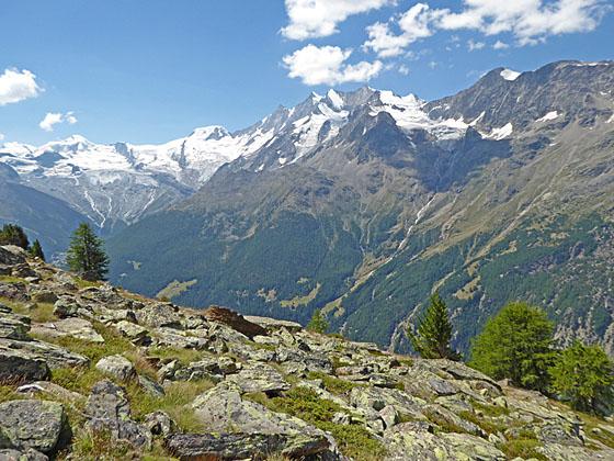
Mischabel panorama
The Gspon Hohenweg is another of the great high routes in the Saas Valley. This scenic trail, traversing high above the east side of the valley, features wonderful panoramic views of the 13,000-ft. (4,000-meter) peaks of the Mischabel Range.
See Trail Detail/Full Description
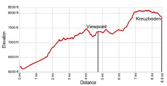
- Distance: 8.6 miles (one way)
- Elevation: 6,260-ft. at Trailhead
Maximum elevation: 8,110-ft. - Elevation Gain: 1,850-ft.
- Difficulty: moderate-strenuous
- More Hikes in:
Saas Fee / The Valais
Why Hike Gspon to Kreuzboden (Gspon Hohenweg)
The panoramic Gspon Hohenweg traverses high above the east side of the Saastal (Saas Valley) with splendid views of the Mischabel Range. The range, separating the Saas Valley from the Mattertal – with Zermatt at it head, is a magnificent wall of mountains with twelve peaks over 13,000-ft. (4,000-meters) high including the Dom – the highest mountain entirely in Switzerland.
Starting in Gspon, a sun-drenched hamlet on the high slopes near the foot of the Saas Valley, the trail travels south/southeast through meadows and forest high above the valley floor with ever evolving views of the Mischabel Range. Initially the Seetalhorn, Bigerhorn and Balfrin dominate the view. Halfway along the route the jagged profiles of the Taschhorn, Dom and Lenzspitze join the stunning scene.
Soon views open to the southwest where the massive Fee Glacier spills down the slopes between the Allalinhorn and Alphubel. These peaks, along with the Taschhorn, Dom and Lenzspitze, form an amazing cirque of 4,000-meter summits surrounding Saas Fee. Huge glaciers cling to the flanks of the peaks while waterfalls, fed by glacial meltwater, gush down the mountainsides.
The trail ends at Kreuzboden where a scenic gondola whisks hikers down to the Saas Gund for a bus ride back to Saas Fee. Purists can walk down to Saas Grund along a very steep trail plunging over 2,700-ft. to the valley floor.
This walk is a slightly easier and shorter alternative to the challenging Saas Fee Hohenweg across the valley, making it a good option for parties looking for a great hike with lovely views. Please note: Due to the up and down nature of the trail, the elevation gain and loss is much greater than it appears by simply looking at the trailhead elevation and the high point on the hike. Total elevation gain for the hike is 2,485-ft and the loss is 2,780-ft.
The trail can be walked in either direction, I recommend walking up valley, from Gspon to Kreuzboden, for the best views.
Elevation Profile
| Support our Site |
Trail Resources
Trail Detail/Full Description / Trail Photo Gallery / Trail Map
Basecamp(s) Information:
Saas Fee
Region Information:
The Valais
Other Hiking Regions in:
Switzerland