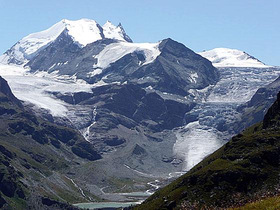
Close-up of the head of the Turtmanntal (Turtmann Valley)
This scenic route between the Val d'Anniviers and Gruben crosses Forcletta Pass and features panoramic views of the high peaks towering above the head of the Zinal and Turtmann Valleys.
See Trail Detail/Full Description
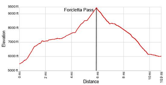
- Distance: 5.9 miles (one way) to Forcletta Pass
10.9 miles (one way) to Complete Hike to Gruben - Elevation: 5,488-ft. at Trailhead
9,424-ft. at Forcletta Pass
5,988-ft. at Complete Hike to Gruben - Elevation Gain: 3,936-ft. to Forcletta Pass
-3,436-ft. to Complete Hike to Gruben - Difficulty: strenuous
- More Hikes in:
Zinal / Gruben / The Valais
Why Hike Zinal to Gruben via Forcletta Pass
Most hikers traveling on the Walker's Haute Route use Meidpass to cross from the Val d'Anniviers to Gruben in the Turtmanntal (Turtmann Valley). In my opinion the trail from Zinal over the Col de la Forcletta (Forcletta Pass) to Gruben is the more scenic option, although it is longer and more strenuous.
From Zinal a steep climb through forest and pastures leads to a high traverse along a narrow shelf on the east side of the Val de Zinal with wonderful views of the high peaks, including Besso, Mont Durand, Pointe de Zinal, Dent Blanche and Grand Cornier, forming the glacial cirque at the head of the Zinal valley. On a clear day the tip of the Matterhorn can be seen peeking above the cirque.
Near the foot of the valley the trail turns east as lovely views open to the peaks rising above Grimentz to the west. Soon the trail ascends pastures to Alp Tsahelet and then travels through meadows before the final short, steep climb to Forcletta Pass.
The pass, on the boundary between the French-speaking Valais and the German-speaking Wallis, enjoys good views of the Bernese Alps to the north and the summits towering above Grimentz to the west. Dominating the skyline to the east is a wall of summits rising above the Turtmann Valley.
From the pass the trail drops steeply down scree covered slopes of the Bluomattalli Valley before turning northeast toward Chalte Berg. As you descend wonderful views of the peaks soaring above the head of the Turtmanntal are gradually revealed.
Below Chalte Berg stunning views open to the Brunegghorn, Bishorn and Tete de Milon rising along the glacial cirque at the head of the valley. The tip of the Weisshorn towers above the cirque. The Turtmann and Brunegg Glaciers, along with several waterfalls, spill down the flanks of the peaks.
After enjoying the spectacle, follow the trail as it descends switchbacks through meadows and then forest to the valley floor. Here the trail turns north, traveling through lovely pastures along the west side of a river to the small, tranquil village of Gruben, nestled beneath the Schwarzhorn.
Note there are no places to purchase food or drink along the trail. Pack a lunch and take plenty of water. Get an early start for the best views. Clouds often obscure the high peaks in the afternoon.
The Hotel Schwarzhorn is a busy little place with a nice restaurant and large backyard for relaxing with a cold beer after a long hike. If is best to have advanced reservations if you plan to spend the night here.
This trail can easily be walked in reverse – from Gruben to Zinal. The hike to Forcletta Pass can also be done as a very steep 11.8 mile (round-trip) day hike from Zinal or a 10 mile (round-trip) hike from Gruben
Elevation Profile
| Support our Site |
Trail Resources
Trail Detail/Full Description / Trail Photo Gallery / Trail Map
Basecamp(s) Information:
Zinal / Gruben
Region Information:
The Valais
Other Hiking Regions in:
Switzerland