Scenic Canyon Walls
This beautiful hike traveling up the South Fork of Mill Creek features soaring sandstone walls, rock art and a perennial stream with lovely cascades and large pools. The South Fork offers more solitude than its sibling the North Fork and is a more interesting hike.
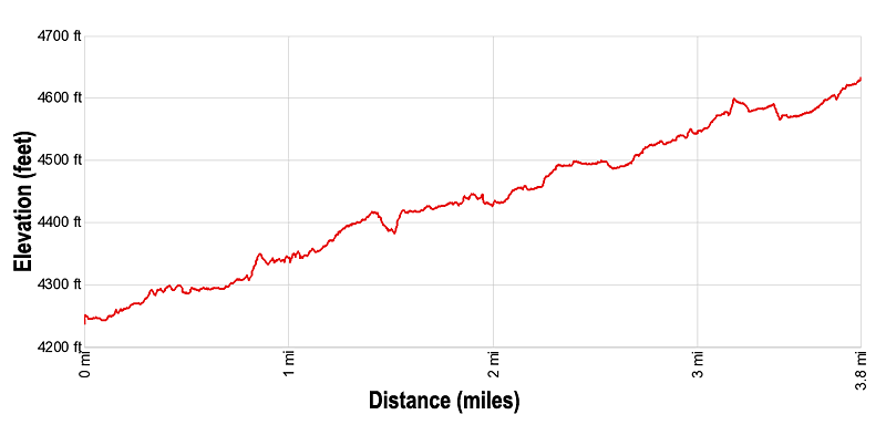
- Distance: 3.0 - 7.6 miles (RT)
- Elevation: 4,240-ft. at Trailhead
Maximum elevation - 4,660-ft. - Elevation Gain: 420-ft.
- Difficulty: easy-moderate
- Basecamp: Moab
- Region: Southeast Utah
Trail Description - Mill Creek (South Fork)
Note: Locals refer to this canyon as the “Right Hand” of Mill Creek while the North Fork of Mill Creek is referred to as the “Left Hand.”
The Mill Creek trail starts at the northeast end of the trailhead parking area. (See driving directions below). This path shares a parking lot with the North Fork of Mill Creek, a very popular trail. Parking is limited so I strongly recommend getting an early start.
From the parking area head east on the wide dirt path, ignoring any trails branching left toward the creek. After about 800-ft. arrive at the base of a small waterfall at the site of an old power plant. Bypass the falls on the right (south), using a slick rock ledge to climb around the cement block dam and then walk along a narrow slickrock shelf beside the creek. Some may find the traction along the angled shelf problematic. If this is the case, wade in the creek.
Soon the canyon widens and a good path travels through grass and sage covered flats along the south side of the creek. Ahead make note of the shallow alcove with the dark background midway up the north canyon wall.
At 0.5 miles the canyon curves to the right. Look up at the shallow alcove to see petroglyphs pecked into the dark desert patina covering the interior of the alcove. A camera with a zoom lens or binoculars will help you get a better view.
At 0.6 miles the canyon narrows as it comes to the confluence of the North and South Forks of Mill Creek. Turn right (south) into the South Fork of Mill Creek. (Ignore the sign pointing straight ahead to the Falls and the North Fork of Mill Creek.)
The initial section of the canyon is narrow and rimmed with sheer walls. A profusion of trees and shrubs grow along the creek. The path briefly travels along the west side of the creek before crossing to the east side. Typically strategically placed rocks in the creek bed will help you keep your feet dry. During periods of high water you will need to wade across the creek. Over the next 0.2 miles the trail will cross the creek two more times.
At 0.8 miles, after the third crossing, the path curves to the left (east) as it travels along a bench, and then to back to the right (southeast), following the curves in the canyon. After a mile the trail again crosses the creek.
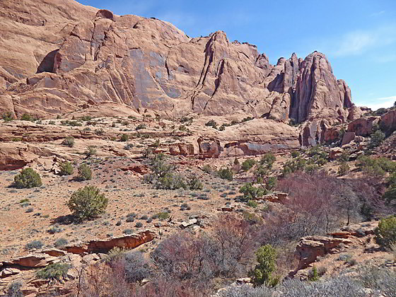
Soon after the crossing the creek the canyon widens and the path now ascends gently across along a scrub clad bench with scenic views of the sheer canyon walls rising to the east. In the distance are the summits of the La Sal Mountains.
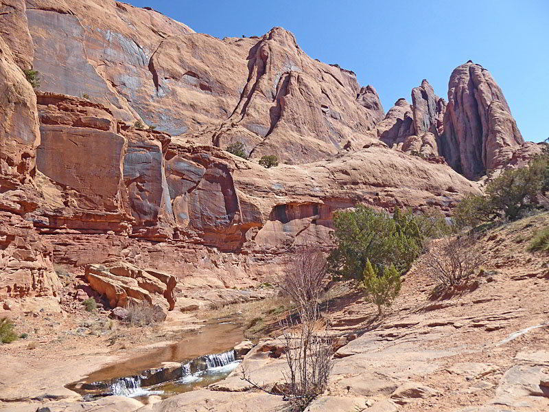
At 1.5 miles the canyon again constricts as it makes another slight jog to the east, soon reaching a beautiful area of deep pools and cascades along the creek. Massive red rock walls tower above the creek. This is another favorite swimming hole and sun bathing spot for the locals. During the cooler weather the area is happily devoid of people and is a wonderful spot for a picnic or simply to sit for a bit admiring the beautiful canyon walls.
At the pools the canyon curves to the left, resuming its southeasterly course. The trail follows suit, following a boot beaten path on the bench along the west side of the creek.
At 1.7 mile reach an area where the creek has sculpted a series of interesting channels and small pools in the slickrock along the valley floor. Here you will also notice trails heading down to and crossing to the east side of the creek. This area of the canyon has trails on both side of the creek. Crossing to the east side will help you spot some small rock art panels along the canyon walls. There is also one larger panel on the west side. My advice is to walk up one side and down the other.
Please do not touch rock art panels as the oil on your fingers can speed the erosion of the rock art. Do not vandalize the panels by taking latex mold prints or rubbings from rock art or adding modern additions.
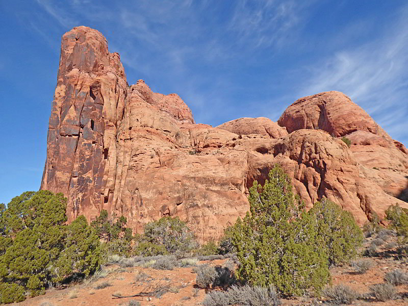
At 2.3 miles the canyon again widens. Here a series of trails along the broad bench on the east side of the canyon travel near the creek or over to the canyon walls. I recommend taking the trails traveling along the canyon walls where you can see a large crevasse between the massive fins forming the canyon’s east wall along with some faint rock art.
As you walk up the canyon look across to the west side of the canyon to see a trail coming down from the rim. This is the Mill Creek Rim trail that crosses the mesa, allowing hikers to loop back to the parking lot. This trail is totally exposed to the sun and can get very hot. Personally, I prefer retracing my steps back along the canyon.
As you progress up the canyon views open to interesting formations, shallow side canyons and pour-offs on both sides of the canyon. There are also a few more small rock art panels.
At 3.0 miles a large bay along the east wall harbors four deep alcoves/caves. Some have soot stains on the ceiling from ancient fires. In other places you will see signs left from modern day campers.
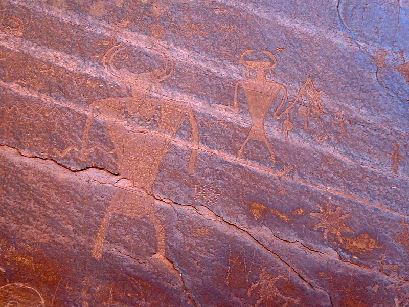
Beyond the caves the trail crosses the creek twice and then skirts an area of thick vegetation and trees. Soon the trail breaks into the open, traveling along a broad bench clad in trees and scrub growth along the east side of the canyon. At 3.75 miles reach a fence/hitching post. Turn left and follow the trail over to a large alcove along the east wall at 3.8 miles. Here you will find a good petroglyph panel.
Return to the fence/hitching post when you are done enjoying the rock art panel. Note that a short trail heads left (south) to a gate and private property. Turn right and retrace your steps down canyon to the trailhead, enjoying the scenic canyon on the hike back to your vehicle.
Elevation Profile
Driving Directions
From Moab, UT: From Center Street and Main Street/US 191 in Moab, head south on S Main Street/ US 191 S for one block and turn left onto E 100 S Street. Follow E 100 S Street for 4 blocks (0.4 miles) and turn right on Fourth East Street. Head south on Fourth East Street for 0.3 miles and turn left onto S Mill Creek Drive. (Dave’s Corner Market is at the corner where you turn.) Follow S Mill Creek east for 0.5 miles and then bear right to stay on South Mill Creek Drive. Continue on South Mill Creek Drive for 0.5 miles and then turn left on Powerhouse Lane. Drive 0.6 miles to the end of the road and the parking area for the Mill Creek Trailhead. The trail starts at the northeast end of the parking area.
This is a popular area and the parking lot fills early on a nice day.
Trail Resources
- Trail Photo Gallery
- Trail Maps
- Basecamp(s) Information: Moab
- Region Information: Southeast Utah
- Other Hiking Regions in: Utah