Kreuzboden to Saas Almagell (Hohenweg Kreuzboden) 
Distance: 6.0 - 6.3 miles (one way)
near Saas Fee in The Valais
This scenic walk, with panoramic views of the Mischabel Range, traverses high above the east side of the Saas Valley before entering the beautiful Almageller Valley. End the hike by descending to Saas Almagell or take the challenging Adventure Trail to Furggstalden.
See Trail Detail/Full Description
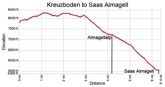
- Distance: 6.3 miles (one way)
- Elevation: 7,872-ft. at Trailhead
Maximum elevation: 8,302-ft. - Elevation Gain: 430-ft.
- Difficulty: moderate
- More Hikes in:
Saas Fee / The Valais
Why Hike Kreuzboden to Saas Almagell (Hohenweg Kreuzboden)
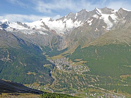
Hohenweg Kreuzboden, aka Hohenweg Almagelleralp, is a panoramic high route in the Saas Valley. The scenic trail traverses the flower-speckled meadows and rugged slopes between the Lagginhorn and Weissmies with splendid views of the Mischabel Range soaring above Saas Fee. As the hike progresses, views open to the Mattmark Dam and the summits ringing the head of the Saas Valley.
Halfway through the hike the trail curves southeast, entering the Almageller Valley. The Portjenhorn and Pizzo d'Andolla rise above the head of the valley while the Almagellerhorn dominates the view to the south. The trail now descends pretty meadows to Almagelleralp on the valley floor. Here hikers will find many lovely spots for a picnic while enjoying the beautiful views.
Parties can opt to continue the hike to Saas Almagell by following a trail dropping steeply through a pretty larch forest or take the challenging Adventure Trail, featuring a 60-meter long swing bridge, to Furggstalden. At Furggstalden a chairlift whisks hikers down to Saas Almagell.
The Adventure Trail is not recommended for small children or anyone with a fear of heights. Sections of the trail are narrow, steep and exposed. Hikers need to scale metal ladders, descend rungs bolted to a cliff face and climb around minor obstacles. The trail is great fun but should only be undertaken by surefooted parties prepared for the challenge.
Elevation Profile

Support our Site | |
Trail Resources
Trail Detail/Full Description / Trail Photo Gallery / Trail Map
Basecamp(s) Information:
Saas Fee
Region Information:
The Valais
Other Hiking Regions in:
Switzerland

